Thursday, September 24, 2015

Dr. Michael Tellinger SHOCKING ENLIGHTENMENT TRUE HISTORY OF EARTH and Discoveries. Wake up!


Dr. Michael Tellinger SHOCKING ENLIGHTENMENT TRUE HISTORY OF EARTH and Discoveries. Wake up

(listen and Research All Testimonies Yourself)

Lets Watch FIRST than Discussed 

Michael Tellinger


Now lets Discussed 


Sound is faster than speed of light Research

Dr. Bill Robertson doesn’t let a little thing like the speed of light limit him. Last summer, researching with two MTSU undergraduates, a high-school teacher and two high-school students, Robertson achieved results that at first seem to fly in the face of one of the most fundamental laws of physics. Using a Rube Goldberg assemblage of regular PVC pipe, a speaker and assorted instruments, the group managed to produce a pulse of sound that exceeded the speed of light. A paper describing his research, “Sound beyond the speed of light: Measurement of negative group velocity in an acoustic loop filter, “ appeared in the January 2007 issue of Applied Physics Letters. The MTSU students involved in the project were physics major Jason Pappafotis and math major Patrick Flannigan. Teacher Jan Cathey and student Brandon Cathey came from Siegel High School; Colin Klaus from Blackman High was the other high school student. Their research was part of STEPmt, a program designed to increase discovery-based learning and undergraduate research in science, technology, engineering and mathematics. After the initial article was published, Robertson’s research was highlighted in several additional scientific publications. It also generated heated discussions on the web. Some bloggers, Robertson said, referred to him in angry and unflattering terms. “People said, ‘This just can’t be right,’” he recalled, taking the criticism in stride. “This doesn’t mean you can call yourself on the phone last Wednesday. It doesn’t violate causality or special relativity. No energy or information travels faster than the speed of light.” Robertson explained that there are “two ways of measuring wave velocity: group velocity and phase velocity. What we were looking at was group velocity.” There’s no easy way to completely explain the phenomenon he has been investigating. As Robertson told his student researchers last summer, “You don’t figure this out on day one. It takes a few weeks to understand what’s going on.” This was not the first time his research has produced intriguing results. In 2002, Robertson, with the help of senior physics and astronomy major Jeremy Munday, used an oscilloscope and other basic laboratory equipment to send an electronic signal at least four times faster than the speed of light. Later that year, a report of the experiment was published in the Sept. 9 issue of Applied Physics Letters. His work is more than an abstract investigation of an odd phenomenon; Robertson’s results have important engineering applications. He cited the example of a computer chip that might send eight separate signals through circuits of different lengths. Applying methods used in his experiments, it’s possible to “manipulate the speed of signals that travel varying paths so they arrive at the same time.” The concepts may be hard to understand, but Robertson’s approach to teaching and research is something everyone, especially students, can appreciate. He enjoys learning and discovery and passes those qualities to his students. One of the things he requires of his students in addition to the traditional tests and quizzes is a special semester project. Many students choose to build a musical instrument and test its acoustics. When projects are presented in December, they reveal a cacophonous assortment of flutes, kazoos, trumpets, xylophones, stringed instruments, electrical tone generators and didgeridoos. A few years ago, one of his students made a didgeridoo for his final project. Fascinated by the acoustics of the droning instrument from the Australian outback, Robertson created a Web page discussing the special acoustics of the instrument. His site drew attention from people all over the world and he has since become somewhat of an expert on the didgeridoo. To read more about Robertson’s latest research, visit www.livescience.com/ technology/070112_ftl_sound.html. An article on his 2002 research on electrical pulses appeared in the September 30, 2002, edition of The Record. It’s available at www.mtsu.edu/~proffice/Record/Rec_v11/rec1106/rec1106.html#Speed. His Web page on the didgeridoo is at http://physics.mtsu.edu/~wmr/didj.html. On that page, one can listen to Robertson play the instrument and view its acoustic spectrum. The Record Feb. 26, 2007 page 3 F 

link to the PDF REPORT FILE

Thursday, September 17, 2015

2014 Ancient Hidden Technology of the Annunaki (Fallen Angels) Amazing !

Documentary Ancient Babylon | The Bible's Buried Secrets | History Chann...

Anonymous Documentary - How Anonymous Hackers Changed the World Full Doc...


See the Growth and inspiration and how Anonymous was sparked, as well the inner and toward growth that not only showed the ugly side of how to really effect change and also the locality and values from just one tiny ideal moral belief that internet shall and will always be freedom of speech and every person has right to say, share, and use freedom of speech. As well the lengths real people will go to protect it.. 

To everyone out there and all that are doing there parts and roles to protect moral values, Thank you all sincerely,  and MAYBE BLESSED with everlasting knowledgeable enlightenment and be blessed. 

For you all, no matter the risk and fear that stood in your way, not once backed down and stood and still fight for a righteous.. moral cause ...
so remember... when  always united  can evolution change that can never be served and shall always remain. as history taught us, Its better to die standing on my feet for my moral belief than to surrender to injustice masses forever in slaved and on my knees. So never surrender, and never give up your moral beliefs..  _Aye Sarita

Wednesday, September 16, 2015

HACKERS of THE SHADOWS, 2nd STRIKE SUCCESSFULLY OBTAINING ALL INFORMATION OF GOVERNMENT OFFICIALS

HACKERS THAT LIVE IN THE SHADOWS, TAKES THERE FIRST STRIKE SUCCESSFULLY OBTAINING ALL INFORMATION OF GOVERNMENT OFFICIALS AND THERE FRIENDS AND FAMILY.  

The New York Times Reports -

U.S. Hacking of Government Computers Exposed 21.5 Million People  Katherine Archuleta, director of the Office of Personnel Management, right, at hearing before the House Oversight and Government Reform Committee last month. 

MARK WILSON / GETTY IMAGES
 By JULIE HIRSCHFELD DAVIS 
JULY 9, 2015 WASHINGTON — 
    The Obama administration on Thursday revealed that 21.5 million people were swept up in a colossal breach of government computer systems that was far more damaging than initially thought, resulting in the theft of a vast trove of personal information, including Social Security numbers and some fingerprints.

   Every person given a government background check for the last 15 years was probably affected, the Office of Personnel Management said in announcing the results of a forensic investigation of the episode, whose existence was known but not its sweeping toll.

     The agency said hackers stole “sensitive information,” including addresses, health and financial history, and other private details, from 19.7 million people who had been subjected to a government background check, as well as 1.8 million others, including their spouses and friends.
    The theft was separate from, but related to, a breach revealed last month that compromised the personnel data of 4.2 million federal employees, officials said.
Both attacks are believed to have originated in China, although senior administration officials on Thursday declined to pinpoint a perpetrator, except to say that they had indications that the same actor carried out the two hacks.

  The breaches constitute what is apparently the largest cyberattack into the systems of the United States government, providing a frightening glimpse of the technological vulnerabilities of federal agencies that handle sensitive information.

   They also seemed certain to intensify debate in Washington over what the government must do to address its substantial weaknesses in cybersecurity, long the subject of dire warnings but seldom acted upon by agencies, Congress or the White House.
 “This incident that we are talking about today is unfortunately not without precedent,” said Michael Daniel, the White House cybersecurity coordinator. “We have to raise our level of cybersecurity in both the private sector and the public sector.” 

  In a conference call to detail the grim findings and announce the agency’s response, Katherine Archuleta, the director of the Office of Personnel Management, said that she would not resign despite calls from members of Congress in both parties for her dismissal.

 “I am committed to the work that I am doing at O.P.M.,” she said. “We are working very hard, not only at O.P.M. but across government, to ensure the cybersecurity of all our systems, and I will continue to do so.”

  She announced new security measures that would be installed at the agency as well as free credit and identity theft monitoring for the victims of the breach, although she said there was “no information at this time to suggest any misuse or further dissemination of the information that was stolen from O.P.M.’s system.”

Even so, national security officials have acknowledged the seriousness of the intrusion. Before the scope was made public on Thursday, James B. Comey, Jr., the director of the F.B.I., called the breach “a very big deal,” noting that the information obtained included people’s addresses; details on their neighbors, friends and relatives; their travel destinations outside the United States; and any foreigners they had come into contact with.

“There is a treasure trove of information about everybody who has worked for, tried to work for or works for the United States government,” Mr. Comey said during a briefing. “Just imagine you are an intelligence service and you had that data, how it would be useful to you.”

Administration officials said it was the personnel office’s work to modernize its computer systems that first led it to detect the breach.

In April, the agency informed the Department of Homeland Security that it had found an intrusion, and the department went to work with the F.B.I. to learn more, said Andy Ozment, a top cybersecurity official at Homeland Security.

 That inquiry, he said, revealed that the intruder had broken into a network at the Interior Department that held a personnel office database, leading to the theft of records of 4.2 million current and former federal employees. It also found that there had been a computer intrusion at the personnel office itself, leading to the much larger trove of background check records.

 Mr. Ozment said the hacker in both cases gained access to the computer systems “via a compromised credential of a contractor.” The debacle has touched off a scramble by federal officials to bolster the security of their networks.

 Tony Scott, the government’s chief information officer, said every agency was racing to make improvements, including the use of basic tools like two-factor authentication that requires anyone with the password to a system to use a second, one-time password to log in from an unrecognized computer. “This is important work across all of the agencies of the federal government to make sure that we greatly enhance the cybersecurity profile of the U.S. government as a whole,” Mr. Scott said. But that effort comes after almost two decades of warnings from government auditors and other internal investigations into the vulnerabilities in federal agency networks.

“There’s still much that agencies need to do that they are not doing to protect their systems,” said Gregory C. Wilshusen, the director of information security issues at the Government Accountability Office, which has conducted cyber audits for almost two decades.

Warnings from auditors about serious vulnerabilities are often ignored by agency officials, he added. “That’s been a recurring theme. They believe they’ve taken corrective actions, but when one goes back to check, we find that they haven’t.” 

    The revelations quickly prompted calls for the ouster of Ms. Archuleta, whose agency had been warned in a series of reports since 2007 about the many vulnerabilities on its antiquated computer systems. Representative Jason Chaffetz, Republican of Utah and the chairman of the House Oversight and Government Reform Committee, said Ms. Archuleta and her top technology official should resign or be removed.

   “Their negligence has now put the personal and sensitive information of 21.5 million Americans into the hands of our adversaries,” Mr. Chaffetz said. “Such incompetence is inexcusable.” The criticism was bipartisan. Senator Mark W. Warner, Democrat of Virginia, also called on Ms. Archuleta to step down. “The technological and security failures at the Office of Personnel Management predate this director’s term, but Director Archuleta’s slow and uneven response has not inspired confidence that she is the right person to manage OPM through this crisis,” Mr. Warner said in a statement.

That attackers were able to compromise the agency using a contractor’s credentials is unacceptable, security experts say, given the wide availability of two-factor authentication tools, which have become standard practice, particularly since a cyberattack at Target nearly two years ago, when hackers managed to break into the retailer’s system using the credentials of a heating and cooling contractor. “A second offense is more unacceptable than the first,” said Suni Munshani, the chief executive of Protegrity, a data security company.

“The O.P.M. and government agencies need to get their act together and better protect the information of their employees and citizens.” Michael D. Shear and Michael S. Schmidt contributed reporting from Washington, and Nicole Perlroth from San Francisco

.

UNTOLD HISTORY of The Life And Death Of Isabella I of Castile- OLD SPAIN


spanish2.gif (25025 bytes)

The Life And Death Of Isabella I of Castile OLD Spain 22 April 1451 -- 26 November 1504), also known as Isabella the Catholic, was queen of Castile and León (Crown of Castile)


Isabella I was born on April 22, 1451 in the town of Madrigal de las Altas Torres.  She died on November 26, 1504 in the castle of La Mota.  She is often referred to as "La Católica" (the Catholic) a "title" given to her by the Spanish Pope, Alexander VI.  This is a title that the Kings and Queens of Spain still retain.  She was the daughter of John II, King of Castile and his second wife, Isabella of Portugal. 
Her father died when she was three and her older brother became King Henry IV.  The Spanish nobles had become very powerful during the reign of John II.  They did not wish to have Henry as their king.   They felt that he was not very smart and would not be a good leader.    They hoped to make Isabella's other brother, Alfonso, their king, but he died on July 5, 1468.  Some people thought that he might have been poisoned to prevent him from being made king.  The nobles then approached Isabella who by now was 17.   She refused the throne saying that she would never become queen while her brother was alive.  Although he had a daughter, King Henry declared Isabella to be the heir to the throne when he died.  It is thought that he did this to make peace with the nobles who had wanted Isabella to be made queen.  They knew that she would be the next ruler of Spain and King Henry knew that he could continue to rule.  But soon Isabella would be at odds with her brother over her impending arranged marriage.
King Henry had wished his sister to marry Don Carlos, the Prince of Viana, who was the eldest son of John II.  He was also heir to the Kingdom of Navarre.  The King of Aragon, wished to marry Isabella to his son, Ferdinand.  Before the final arrangements could be made, Don Carlos died.  Henry tried to arrange marriages with several other people including King Alfonso V of Portugal, but Isabella had already decided that she wished to marry Ferdinand.  
Her brother was so mad that he threatened to throw her in the dungeon.  But because of her powerful supporters he knew he could not do that.  Instead he made her promise
italy.gif (22106 bytes)

My Family Crest passed down thru out the ages


that she would not make any plans to marry until he had returned from Andalusia.  However almost as soon as he had left, Isabella made plans to marry Ferndinand.  The only problem was that she had to find him. She sent out noblemen to search for him and he was finally found in Sicily (the island at the bottom of Italy) where he had become King.  He has also now become heir to the throne of Aragon. 

He braved a trip back to Spain and married Isabella in 1469 in the palace of Juan de Vivero.
King Henry was mad at his sister, but his new brother-in-law was after all the future King of Aragon. 
 Henry ruled for only 5 more years before he died in 1474 in Madrid.  Isabella was then declared Queen of Castile.   However, before he had died, Henry had arranged his daughter Joan to be married to King Alfonso V of Portugal. 
 He also made his daughter the heir to the throne.


Because there was now there was uncertainty of who was the rightful Queen , Castile and Aragon went to war with Portugal.  The war last for five years and ending in peace in 1479 with an alliance between the Kingdoms.  As part of the peace treaty, Joan abandoned her claim to the throne, making Isabella Queen of Spain.   During this period, Ferdinand became King Ferdinand II of Aragon.  Isabella once again showed her great abilities when she decided that Ferdinand and herself would equally rule the two Kingdoms.  She created the motto "Tanto monta, monta tanto - Isabel como Fernando" (As much as the one is worth so much is the other - Isabella as Ferdinand).


Now that Isabella and Ferdinand were rulers they set out to achieve some goals.  One was the lessening of the power of the nobles who Isabella had thought had become too powerful.  They created an organization "Santa Hermandad" (Holy Brotherhood) which was a type of permanent military force.  It was paid for by the communities and was intended for the protection of persons and property against the violence of the nobles.  They also re-organized the courts and the administration of justice.  They removed the rights of certain people to make coins.  This made it easier for business because only one type of coin would be used.  They took away some of the lands previously given to the nobles and also destroyed some of their castles which they felt was a menace to public peace.
Because they were both devoutly Catholic, they felt that they had to rid Spain of anyone who was not Catholic.  Or at least get them to convert.  For such reason they got Pope Sixtus IV to establish the Spanish Inquisition in 1478.


The Spanish Inquisition, which officially lasted until 1808, was not a good period for Spain.  It was particularly bad during the reign of Isabella and Ferdinand.  Anyone who was not a Catholic was suspected of being against the church.  They risked torture and death if they did not renounce their own religion and become a Catholic.  Unfortunately even converting was not good enough for the Chief Inquisitor, Torquemada.  He convinced, Isabella and Ferdinand that the Jewish people posed a threat to their Kingdoms, even those that had previously converted.  As such on March 31, 1492 Isabella and Ferdinand ordered that by July 1st all people of the Jewish faith had to leave Spain or be put to to death. 


Some of these people secretly remained in Spain, some settled in Portugal or went to North Africa.  And some decided that they would leave Spain as far behind as possible.  They decided to join with a sea captain who was looking for sailors to help him find a new western route to India.  The name of the sea captain was Christopher Columbus.


Columbus had actually been asking for money to support his trip for several years.  He was Italian so he first asked for money from the rulers of the cities of Genoa and Venice in Italy. He then asked the King of Portugal. He tried Isabella and Ferdinand but they had been turning his request down because they still had one more problem they needed to handle.
A portion of Spain was still under control of the Arabs (Moors).  This was the area of Granada.  By January 1, 1492, Granada was under their control.  In contrast to the way that they had treated their Jewish citizens, they treated the Moors quite well.  In the Treaty of Granada they allowed them to freely practice their religion and even be exempt from taxation for a number of years.Now that the problem of Granada was solved they began to listen to Columbus and his plans to find a new route to India.  A route not by sailing east around Africa, but rather west across unknown waters.  They also decided that it would not cost too much money to pay for the trip and the rewards might be quite grand.  The person who was in charge of the Royal Treasury said the cost of the trip (3 ships and crew) would be about what is cost them to entertain a visiting noble for one week. 


On August 3, 1492 Columbus set sail with three ships the Niña, the Pinta and  the Santa Maria and 87 men.  (The flag of the main ship, the Santa Maria is shown on the left.)

Columbus reached America on October 12, 1492.   Actually he had not been sailing for all that time.  He had first arrived in the Canary Islands and left them on September 6th.  He did not find a new route to India, but found for Spain a land rich with gold, silver and spices.  He was convinced that he had found a new route to Asia and the East Indies.  He thought that Cuba was actually somewhere in Asia and that the island of Hispanola (where the Dominican Republic and Haiti are now located) was just off the coast of China.  He also found the native people.  He supposedly called them Indians because he thought they were from the Indies.
Columbus returned to Spain in 1493 bringing with him not only treasures, but also some of these natives.  (The picture on the left is a panel from the main door of the US Capital.  It is called the Columbus Door and has 8 panels showing scenes from Columbus' life.  Just in front of Columbus you can see two of the Native American people.)  Queen Isabella became the protector of the Native Americans.  Queen Isabella established laws against the abuse of the Native American people by colonists and adventurers.
During this time Spain began its rise into greatness.  This was the beginning of the "Golden Age" of Spain.   Discovers such as Columbus were bringing them riches, their agriculture prospered, they became great manufactures of cloths, glass, steel weapons and leather goods.   This could not have been achieved without Queen Isabella.  She was able to see the potential of Columbus.  Her laws and the fair way she treated her citizens (with the exception of her horrible treatment of the Jewish citizens)  enabled Spain to be at peace internally.  Her strong army and navy made Spain a world power and a great trading power.  The Spanish she spoke is still used by the Spanish Royal Academy as the standard for the language.
Isabella and Ferdinand had 5 children, four girls and 1 boy.  They were Isabella, John, Joan, Maria and Catherine.   Isabella not only made sure that the girls were well educated (which was unusual for that time), but also that they knew how to do such things as sewing.  The children actually made most of their father's clothing.  She herself would often mend her husband's and children's clothing.  Unfortunately she was not able to enjoy much happiness with her children.  Her son died in 1497.  Her daughter, Isabella became Queen of Portugal, but she died in 1498 while giving birth.  Her son (Isabella's grandson), Miguel died when he was three.  Catherine married King Henry VIII of England, but he divorced her when she was unable to produce a male heir.  Joan, who was to inherit the throne became crazy.

Although she co-ruled with her husband, it was actually her that was the better ruler.  Her husband did bring to their marriage the Kingdom of Aragon which enabled them to unite Spain.   If the two Kingdoms remained separate it would have been doubtful that Spain could have achieved it greatness.  But just uniting Spain did not enable it to become this great power.  It needed a ruler such as Isabella who had the skill to guide and to make Spain a great country. 


Isabella died on November 26, 1504 in Medina del Campo.  In her will she asked that her successors protect and treat the people of the Americas the same as they would the Spanish people.  Her husband continued to rule for 12 more years until he died in Madrigalejo on January 23, 1516.  He was succeeded to the throne by his grandson, who was the son of his daughter Joan.  This person was to become Holy Roman Emperor Charles V.

Who knew America had a 4 dollar bills... the things we learn. pretty cool.

What Lead my research to discover this untold history of Old Spain.....


Modern-day Clarification Definition of Empathy vs Sympathy

Empathy vs. Sympathy

The terms and empathy and sympathy are often confused, and with good reason. Both of the words deal with the relationship one has to the feelings and experiences of another.
Today we explore the differences between these terms and how they are most commonly used.
Both sympathy and empathy have roots in the Greek term páthos meaning “suffering, feeling.” The prefix sym- comes from the Greek sýn meaning “with, together with” and the prefix em- derives from the Greek en- meaning “within, in.”

Sympathy is the older of the two terms. It entered English in the mid-1500s with a very broad meaning of “agreement or harmony in qualities between things or people.” 
Since then, the term has come to be used in a more specific way.
Nowadays sympathy is largely used to convey commiseration, pity, or feelings of sorrow for someone who is experiencing misfortune.
This prevailing sense is epitomized in the category of greeting card most often labeled “sympathy” that specializes in messages of support and sorrow for those in a time of need.
Consider the following examples: “There was little sympathy in England for David Beckham … when he received a red card in a 1998 World Cup loss to Argentina.” –New York Times, July 2, 2015 
“…the new [Facebook] feature would automatically replace the existing ‘like’ button with a ‘sympathize’ one when users tag their statuses with a negative emotion, like ‘sad’ or ‘depressed.’” –New York, December 6, 2013

  Empathy entered English a few centuries after sympathy—in the late 1800s—with a somewhat technical and now obsolete meaning from the field of psychology, which referred to the physiological manifestation of feelings
  Unlike sympathy, empathy has come to be used in a more broad way than it was when it was first introduced into the lexicon; the term "empathy" is now most often used to refer to the capacity or ability to imagine oneself in the situation of another, thereby vicariously experiencing the emotions, ideas, or opinions of that person
  Consider the following examples: “…many of us believe that if more lives are at stake, we will — and should — feel more empathy (i.e., vicariously share others’ experiences) and do more to help.” –New York Times, July 10, 2015 
“I think that’s almost what it is sometimes if you sum up what acting is. It’s just the ultimate expression of empathy.” –Emily Blunt, Los Angeles Times, December 8, 2014

  To sum up the differences between the most commonly used meanings of these two terms:

sympathy is feeling compassion, sorrow, or pity for the hardships that another person encounters,

                 while.....

 empathy is putting yourself in the shoes of another.


Tuesday, September 15, 2015

Antarctic Ice Glaciers as of 2015 depolarization begun


What The Heck is Larson B???
Well... its located in Greenland


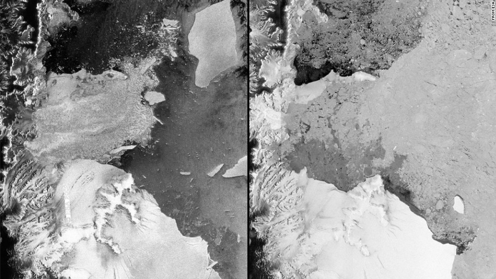
One of the last remaining sections of Antarctica's Larsen B Ice Shelf is dramatically weakening, according to anew NASA study.
The study predicts that what remains of the once-prominent ice shelf, a thick floating platform of ice, most likely will "disintegrate completely" before the end of this decade
Ice shelves are extensions of glaciers and function as barriers. Their disappearance means glaciers potentially will diminish more quickly, as well, increasing the pace at which global sea levels rise.
European Space Agency satellite images from 2002, left, and 2012 reveal the disintegration of the Antarctic ice shelf.
A team led by Ala Khazendar of NASA's Jet Propulsion Laboratory in Pasadena, California, found evidence of the ice shelf flowing faster and becoming more fragmented. The flow is creating large cracks in the ice shelf.
"These are warning signs that the remnant is disintegrating," Khazendar said in a NASA press release. "Although it's fascinating scientifically to have a front-row seat to watch the ice shelf becoming unstable and breaking up, it's bad news for our planet."
The Larsen B Ice Shelf has existed for at least 10,000 years.
    The ice shelf's disintegrating state came into light after it partially collapsed in 2002. Scientists watched in amazement as the ice shelf splintered and vanished rapidly in six weeks. No one had ever witnessed a large ice mass disappear so quickly, according to Eric Holthaus, a meteorologist at Slate.
    The collapse of the Larsen B Ice Shelf seems to have been caused by a series of warm summers on the Antarctic Peninsula, which happen during what in the Northern Hemisphere are winter months. Those trends built up to a particularly warm summer in 2002, according to NASA.
    Larsen B measured 4,445 square miles in January 1995. It went down to 2,573 square miles in February 2002 after the major disintegration, and a month later Larsen B was down to 1,337 square miles.
    At present the Larsen B remnant is about 618 square miles. That's less than half the size of Rhode Island, the smallest U.S. state. Two decades ago, Larsen B was slightly smaller than the state of Connecticut.
    NASA's Jet Propulsion Laboratory glaciologist Eric Rignot, who co-authored the paper, said the research gives insight into how ice shelves closer to the South Pole will react with the warming climate.
    "What is really surprising about Larsen B is how quickly the changes are taking place," Khazendar said. "Change has been relentless."
    Ice shelves are particularly sensitive to atmospheric warming and changes to ocean temperature, said Helmut Rott from the University of Innsbruck after the European Space Agency observed a rapid retreat of Larsen B Ice Shelf in April 2012 via satellite images.
    Other prominent ice shelves in the region also have been affected over the years.
    Larsen A disintegrated in January 1995. Larsen C has been somewhat stable with some evidence of thinning and melting, the space agency said after observing satellite imagery in 2012.

    2015 Arctic sea ice maximum lowest measured since records began being kept in 1979. Maximum took place in February, 15 days earlier than the 1981-2010 average.
    The National Snow & Ice Data Center announced this past week (March 19, 2015) that 2014-2015’s Arctic sea ice maximum extent was the lowest yet recorded. In addition, sea ice likely hit its maximum extent nearly two weeks earlier than in recent decades, on February 25, 2015. It happened even as unusually cold air and stormy weather occurred across the eastern half of the United States and Canada this year.
    Arctic sea ice always grows during the winter months with the greatest ice coverage around March 12 in a typical year of the past couple of decades. However, since February 25 of this year, Arctic sea ice has been melting.
    So 2011-2012 no longer holds the record for smallest maximum extent of Arctic sea ice. 2014-2015 is the new champion. Why is that, and what does that mean?
    Here the 2015 maximum is compared to the 1979-2014 average maximum shown in yellow. A distance indicator shows the difference between the two in the Sea of Okhotsk north of Japan. Image via NASA's Goddard Space Flight Center
    Here the 2015 maximum is compared to the 1979-2014 average maximum shown in yellow. A distance indicator shows the difference between the two in the Sea of Okhotsk north of Japan. Image via NASA’s Goddard Space Flight Center
    The blue line indicates the current Arctic Sea Ice extent. Image Credit: National Snow & Ice Data Center
    The blue line indicates the current Arctic sea ice extent. Image via National Snow & Ice Data Center
    Every winter, Arctic sea ice grows as temperatures cool. Ice grows in the fall and winter months, and melts during the spring and summer months. This cycle always occurs, and, in the decades since 1979, scientists have been able to monitor the speed and growth of the ice over time. Sea ice grew to 14.54 million square kilometers (5.61 million square miles) on February 25, 2015. If we added an additional 1.10 million square kilometers (425,000 square miles) of sea ice to the Arctic right now, we would be at the average sea ice extent for the 1981-2010 period.
    The lowest Arctic sea ice extent recorded before 2014-2015 was back in 2011-2012 when sea ice was 50,000 square miles greater at maximum than it was this year. According toAndrew Freedman of Mashable, the diminishment of sea ice this winter was an area equivalent to that of Texas and California combined.
    Sea ice loss for 2014-2015 winter was roughly the size of Texas and California combined. Image Credit: WSI/MAX
    There was less Arctic sea ice in 2014-2015 winter – compared to the previous lowest maximum extent – by an area about the size of Texas and California combined. Image via WSI/MAX
    The peak of sea ice growth in the Arctic occurred 15 days earlier in 2015 than the 1981 to 2010 average date of March 12. What was responsible for the early peak of sea ice extent in the Arctic?
    It can be blamed upon the crazy jet stream pattern that formed across North America in February. Unusually cold air and stormy weather developed along the jet stream across the eastern half of the United States and Canada. Meanwhile, sunny and above average temperatures occurred across the western United States, Canada, and into Alaska. The highly amplified weather pattern supplied warm conditions over the Pacific side of the Arctic that brought upon low sea ice extent in the Bering Sea and the Sea of Okhotsk.
    Finally, we were in a strong Arctic Oscillation, or weather pattern that brought upon warm, southerly winds across the eastern Arctic thanks to an area of low pressure situated across Iceland and southern Greenland and extending into the Barents Sea.
    With such an amplified jet stream transferring cooler temperatures across the eastern half of the United States and Canada, it gave the Arctic very little room to stay cold and grow more sea ice extent.
    Jet stream orientation was one reason as to why the Arctic Sea Ice was small this winter. Image Credit: WSI/MAX
    Jet stream orientation in winter 2015 was one reason Arctic Sea Ice was so puny this winter. Image via WSI/MAX
    What does this mean about the sea ice extent as we head into the warm months? It’s still much too early to determine whether or not sea ice will reach a record minimum extent in 2015.
    The extent of sea ice melt will depend on the thickness of the ice. Thin ice will melt faster. If there is more open water, the heat from the sun will be absorbed faster and sea ice melt could accelerate. It all depends on atmospheric features and what develops over the next several months. It is predicted that we could see an Arctic Ocean completely free of sea ice in the next couple of decades as carbon dioxide and greenhouse gases continue to grow and the planet warms as a whole. Melting of sea ice will not affect sea level rise, but it could result in unusual weather patterns across the Northern Hemisphere.
    Sea ice extent across the Arctic on March 19, 2015. Credit: Department of Illinois at Urbana-Champaigne Polar Research Group
    Sea ice extent across the Arctic on March 19, 2015. Credit: Department of Illinois at Urbana-Champaigne Polar Research Group
    I constantly hear the zombie (walking dead!) declaration that Antarctica has the greatest sea ice extent since record-keeping began and, thus, the world as a whole cannot be warming.
    While it’s true that Antarctica continues to have record sea ice extent, it’s important to note what that actually means. Sea ice is different than land ice. Melting of sea ice will not contribute to sea level rise. If you have ice melt in your glass of water, the volume stays the same.
    Meanwhile, if you drop a bunch of ice cubes into your glass of water, the water level goes up. The same is true of sea level, and that is the real story of what’s happening in Antarctica in this century. In Antarctica, we are seeing glaciers and ice sheets melt into the sea.
    The video below, from NASA, has more details about this year’s record sea ice Arctic sea ice extent.
    https://youtu.be/4Kvd-uquuhI
    Iceland the new god Utopia
    Special THANKS to and four speaking up... 
    thank you!!! 30 second to Mars- A beautiful lie


    full science report


    http://www.sciencedirect.com ScienceDirect RSS en-us Copyright © 2014 <A href="http://www.elsevier.com/" title="Elsevier B.V. (Opens new window)" target="_blank">Elsevier B.V.</A> All rights reserved. SciVerse ® is a registered trademark of Elsevier Properties S.A., used under license. ScienceDirect ® is a registered trademark of Elsevier B.V. http://rss.sciencedirect.com/images/logo_rss_SD.png http://wwncedirect.comhttp://rss.sciencedirect.com/action/redirectFile?&zone=main&currentActivity=feed&usageType=outward&url=http%3A%2F%2Fwww.sciencedirect.com%2Fscience%3F_ob%3DGatewayURL%26_origin%3DIRSSSEARCH%26_method%3DcitationSearch%26_piikey%3DS0012821X15005294%26_version%3D1%26md5%3D7bb234b5ad3c4f0f599d769f2aef1d9115 November 2015
    Source:Earth and Planetary Science Letters, Volume 430

    Author(s): Youqiang Yu, Stephen S. Gao, Moikwathai Moidaki, Cory A. Reed, Kelly H. Liu

    This study represents the first shear-wave splitting investigation of the Okavango rift zone (ORZ), an incipient continental rift belonging to the East African rift system in northern Botswana. Analysis of broadband seismic data recorded along a 750 km long profile of 22 stations traversing the ORZ and adjacent Congo and Kalahari cratons and several Precambrian orogenic zones reveals dominantly NE–SW fast orientations, which are parallel to both the absolute plate motion direction (based on the NNR-NUVEL-1A model) and the trend of most tectonic boundaries, including that of the ORZ. Spatial coherence analysis of the splitting parameters and correspondence between the observed fast orientations and the trend of tectonic features indicate that the main source of observed anisotropy is most likely in the upper asthenosphere, probably due to simple shear associated with the relative movement of the lithosphere against the asthenosphere. The presence of consistently rift-parallel fast orientations and normal splitting times in the ORZ and most parts of southern Africa implies that neither an upper mantle plume nor small-scale convection is the dominant source for rift initiation and development. The first shear-wave splitting measurements in the vicinity of the ORZ favor a model in which continental rifting develops in response to intra-plate relative movement of continental blocks along zones of weakness produced by ancient tectonic events. 


    ]]>
     Wed, 16 Sep 2015 20:31:32 GMT http://rss.sciencedirect.com/action/redirectFile?&zone=main&currentActivity=feed&usageType=outward&url=http%3A%2F%2Fwww.sciencedirect.com%2Fscience%3F_ob%3DGatewayURL%26_origin%3DIRSSSEARCH%26_method%3DcitationSearch%26_piikey%3DS0012821X15005294%26_version%3D1%26md5%3D7bb234b5ad3c4f0f599d769f2aef1d912015-09-16T20:31:32Z 
    http://rss.sciencedirect.com/action/redirectFile?&zone=main&currentActivity=feed&usageType=outward&url=http%3A%2F%2Fwww.sciencedirect.com%2Fscience%3F_ob%3DGatewayURL%26_origin%3DIRSSSEARCH%26_method%3DcitationSearch%26_piikey%3DS0012821X15005208%26_version%3D1%26md5%3Dc844a216338b91984c3423901e79386415 November 2015
    Source:Earth and Planetary Science Letters, Volume 430

    Author(s): Nicolas Flament, Michael Gurnis, R. Dietmar Müller, Dan J. Bower, Laurent Husson

    The Cenozoic evolution of South American topography is marked by episodes of large-scale uplift and subsidence not readily explained by lithospheric deformation. The drying up of the inland Pebas system, the drainage reversal of the Amazon river, the uplift of the Sierras Pampeanas and the uplift of Patagonia have all been linked to the evolution of mantle flow since the Miocene in separate studies. Here we investigate the evolution of long-wavelength South American topography as a function of subduction history in a time-dependent global geodynamic model. This model is shown to be consistent with these inferred changes, as well as with the migration of the Chaco foreland basin depocentre, that we partly attribute to the inboard migration of subduction resulting from Andean mountain building. We suggest that the history of subduction along South America has had an important influence on the evolution of the topography of the continent because time-dependent mantle flow models are consistent with the history of vertical motions as constrained by the geological record at four distant areas over a whole continent. Testing alternative subduction scenarios reveals flat slab segments are necessary to reconcile inferred Miocene shorelines with a simple model paleogeography. As recently suggested, we find that the flattening of a subduction zone results in dynamic uplift between the leading edge of the flat slab segment and the trench, and in a wave of dynamic subsidence associated with the inboard migration of the leading edge of flat subduction. For example, the flattening of the Peruvian subduction contributed to the demise of Pebas shallow-water sedimentation, while continental-scale tilting also contributed to the drainage reversal of the Amazon River. The best correlation to P-wave tomography models for the Peruvian flat slab segment is obtained for a case when the asthenosphere, here considered to be 150 km thick and 10 times less viscous than the upper mantle, is restricted to the oceanic domain. 


    ]]>
     Wed, 16 Sep 2015 20:31:32 GMT http://rss.sciencedirect.com/action/redirectFile?&zone=main&currentActivity=feed&usageType=outward&url=http%3A%2F%2Fwww.sciencedirect.com%2Fscience%3F_ob%3DGatewayURL%26_origin%3DIRSSSEARCH%26_method%3DcitationSearch%26_piikey%3DS0012821X15005208%26_version%3D1%26md5%3Dc844a216338b91984c3423901e7938642015-09-16T20:31:32Z 
    http://rss.sciencedirect.com/action/redirectFile?&zone=main&currentActivity=feed&usageType=outward&url=http%3A%2F%2Fwww.sciencedirect.com%2Fscience%3F_ob%3DGatewayURL%26_origin%3DIRSSSEARCH%26_method%3DcitationSearch%26_piikey%3DS0012821X1500518X%26_version%3D1%26md5%3D0600de21f1450f1c31d061a93e73229d15 November 2015
    Source:Earth and Planetary Science Letters, Volume 430

    Author(s): Osamu Ishizuka, Rex N. Taylor, Nobuo Geshi, Teruki Oikawa, Yoshihisa Kawanabe, Itaru Ogitsu

    To discover how magmas move and interact beneath an arc we have examined the temporal and spatial evolution of the largest Izu-Bonin frontal arc volcano Izu-Oshima and the adjacent Izu-Tobu field of backarc volcanoes. Extensive 14C ages and geochemical analysis of subaerial satellite cones as well as other effusives has enabled us to construct a well-constrained  14   ka record of Izu-Oshima volcanism. The geochemistry of Izu-Oshima is found to change systematically through the last 14 000 yr. Ba/La, Pb/Ce, 87Sr/86Sr, 143Nd/144Nd and 206Pb/204Pb all decrease between 10 ka and 5 ka before increasing between 5 ka and the present, while La/Yb and Nb/Zr show the reverse. These changes in composition match the addition of Izu-Tobu (backarc) magma to the Izu-Oshima plumbing system with a maximum of a 40% Izu-Tobu at around 5 ka. Progressive but asymptotically declining changes in composition through the 10–5 ka period are found to fit a model where pre-mixed magma is episodically added to, and mixed with, a chamber beneath Izu-Oshima. The 5–0 ka period reverses this trend, but is again progressive and declining, suggesting a switch to a progressive influx of pure Izu-Oshima frontal arc magma. Combining flux and eruption volume estimates with the observed geochemical mixing rates indicates that the accessible melt volume of the Izu-Oshima magma system is  16  km 3 . Interaction and pre-mixing between the fluid-dominated frontal arc melt and the sediment-bearing backarc magmas must occur at deeper levels within the arc crust. This deep reservoir receives a continuous feed from the frontal arc mantle, but may periodically intercept rising magmas from the backarc source to produce episodes of magma mixing on timescales of  5000   yr .This study demonstrates that interaction between frontal arc and backarc magma needs to be considered to achieve better understanding of material transfers and elemental budgets at subduction zones. 


    ]]>
     Wed, 16 Sep 2015 20:31:32 GMT http://rss.sciencedirect.com/action/redirectFile?&zone=main&currentActivity=feed&usageType=outward&url=http%3A%2F%2Fwww.sciencedirect.com%2Fscience%3F_ob%3DGatewayURL%26_origin%3DIRSSSEARCH%26_method%3DcitationSearch%26_piikey%3DS0012821X1500518X%26_version%3D1%26md5%3D0600de21f1450f1c31d061a93e73229d2015-09-16T20:31:32Z 
    http://rss.sciencedirect.com/action/redirectFile?&zone=main&currentActivity=feed&usageType=outward&url=http%3A%2F%2Fwww.sciencedirect.com%2Fscience%3F_ob%3DGatewayURL%26_origin%3DIRSSSEARCH%26_method%3DcitationSearch%26_piikey%3DS0012821X15005154%26_version%3D1%26md5%3D1f7925e10e46512386533b503b1f5ba915 November 2015
    Source:Earth and Planetary Science Letters, Volume 430

    Author(s): Annette Schroeder, Martin G. Wiesner, Zhifei Liu

    In order to assess dominant settling processes that change the composition of the detrital clay fraction during transport from neighboring estuaries to a deep sea basin, we studied relative clay mineral abundances and absolute clay mineral fluxes of clay-sized sinking particulate matter collected by eight sediment trap systems deployed from shallow to deep water depth in the South China Sea. This is the first basin-wide study on recent sedimentation processes in the western Pacific marginal seas. Annual averages of relative clay mineral abundances at the shallow traps are temporally more variable and regionally more diverse, resembling those of surrounding drainage basins. In contrast, higher fluxes of material reach the deeper traps. Their characteristics trend temporally and spatially towards uniformity and are enriched with smectite in the entire deep basin. Sinking particulate matter that reaches the shallow traps spends less time in pelagic transport and is affected by monsoonal current reversals. The enrichment in smectite in the deeper traps is a result of longer duration in transport at low velocities, which may increase the effect of differential settling during transport. The trend is caused by lateral advection driven by the cyclonic deep circulation, and this is considered as the main transport process in the northern and central deep basin. The high fluxes in the south-western deep basin could be the result of laterally advected re-suspended sediments from the neighboring shelves. The effects on the composition of the detrital clay fraction caused by oceanographic control, which indirectly include those by differential settling, mask the climatic signal from surrounding drainage basins in the deep basin sediments. This strongly affects the interpretation of the clay mineralogical record in sediments deposited under recent conditions in the South China Sea deep basin. 


    ]]>
     Wed, 16 Sep 2015 20:31:32 GMT http://rss.sciencedirect.com/action/redirectFile?&zone=main&currentActivity=feed&usageType=outward&url=http%3A%2F%2Fwww.sciencedirect.com%2Fscience%3F_ob%3DGatewayURL%26_origin%3DIRSSSEARCH%26_method%3DcitationSearch%26_piikey%3DS0012821X15005154%26_version%3D1%26md5%3D1f7925e10e46512386533b503b1f5ba92015-09-16T20:31:32Z 
    http://rss.sciencedirect.com/action/redirectFile?&zone=main&currentActivity=feed&usageType=outward&url=http%3A%2F%2Fwww.sciencedirect.com%2Fscience%3F_ob%3DGatewayURL%26_origin%3DIRSSSEARCH%26_method%3DcitationSearch%26_piikey%3DS0012821X15005270%26_version%3D1%26md5%3Dabfa5e804ba3cab1d90de1112b27d27615 November 2015
    Source:Earth and Planetary Science Letters, Volume 430

    Author(s): Aaron M. Satkoski, Nicolas J. Beukes, Weiqiang Li, Brian L. Beard, Clark M. Johnson

    Before the Great Oxidation Event (GOE) 2.4–2.2 billion years ago it has been traditionally thought that oceanic water columns were uniformly anoxic due to a lack of oxygen-producing microorganisms. Recently, however, it has been proposed that transient oxygenation of shallow seawater occurred between 2.8 and 3.0 billion years ago. Here, we present a novel combination of stable Fe and radiogenic U–Th–Pb isotope data that demonstrate significant oxygen contents in the shallow oceans at 3.2 Ga, based on analysis of the Manzimnyama Banded Iron Formation (BIF), Fig Tree Group, South Africa. This unit is exceptional in that proximal, shallow-water and distal, deep-water facies are preserved. When compared to the distal, deep-water facies, the proximal samples show elevated U concentrations and moderately positive δ 56Fe values, indicating vertical stratification in dissolved oxygen contents. Confirmation of oxidizing conditions using U abundances is robustly constrained using samples that have been closed to U and Pb mobility using U–Th–Pb geochronology. Although redox-sensitive elements have been commonly used in ancient rocks to infer redox conditions, post-depositional element mobility has been rarely tested, and U–Th–Pb geochronology can constrain open- or closed-system behavior. The U abundances and δ 56Fe values of the Manzimnyama BIF suggest the proximal, shallow-water samples record precipitation under stronger oxidizing conditions compared to the distal deeper-water facies, which in turn indicates the existence of a discrete redox boundary between deep and shallow ocean waters at this time; this work, therefore, documents the oldest known preserved marine redox gradient in the rock record. The relative enrichment of O2 in the upper water column is likely due to the existence of oxygen-producing microorganisms such as cyanobacteria. These results provide a new approach for identifying free oxygen in Earth's ancient oceans, including confirming the age of redox proxies, and indicate that cyanobacteria evolved prior to 3.2 Ga. 


    ]]>
     Wed, 16 Sep 2015 20:31:32 GMT http://rss.sciencedirect.com/action/redirectFile?&zone=main&currentActivity=feed&usageType=outward&url=http%3A%2F%2Fwww.sciencedirect.com%2Fscience%3F_ob%3DGatewayURL%26_origin%3DIRSSSEARCH%26_method%3DcitationSearch%26_piikey%3DS0012821X15005270%26_version%3D1%26md5%3Dabfa5e804ba3cab1d90de1112b27d2762015-09-16T20:31:32Z 
    http://rss.sciencedirect.com/action/redirectFile?&zone=main&currentActivity=feed&usageType=outward&url=http%3A%2F%2Fwww.sciencedirect.com%2Fscience%3F_ob%3DGatewayURL%26_origin%3DIRSSSEARCH%26_method%3DcitationSearch%26_piikey%3DS0012821X15005166%26_version%3D1%26md5%3Df1f522d8d68d7cda77d3b429ac73f54c15 November 2015
    Source:Earth and Planetary Science Letters, Volume 430

    Author(s): J. Dyment, Y. Choi, M. Hamoudi, V. Lesur, E. Thebault

    As a by-product of the construction of a new World Digital Magnetic Anomaly Map over oceanic areas, we use an original approach based on the global forward modeling of seafloor spreading magnetic anomalies and their comparison to the available marine magnetic data to derive the first map of the equivalent magnetization over the World's ocean. This map reveals consistent patterns related to the age of the oceanic lithosphere, the spreading rate at which it was formed, and the presence of mantle thermal anomalies which affects seafloor spreading and the resulting lithosphere. As for the age, the equivalent magnetization decreases significantly during the first 10–15 Myr after its formation, probably due to the alteration of crustal magnetic minerals under pervasive hydrothermal alteration, then increases regularly between 20 and 70 Ma, reflecting variations in the field strength or source effects such as the acquisition of a secondary magnetization. As for the spreading rate, the equivalent magnetization is twice as strong in areas formed at fast rate than in those formed at slow rate, with a threshold at ∼40 km/Myr, in agreement with an independent global analysis of the amplitude of Anomaly 25. This result, combined with those from the study of the anomalous skewness of marine magnetic anomalies, allows building a unified model for the magnetic structure of normal oceanic lithosphere as a function of spreading rate. Finally, specific areas affected by thermal mantle anomalies at the time of their formation exhibit peculiar equivalent magnetization signatures, such as the cold Australian–Antarctic Discordance, marked by a lower magnetization, and several hotspots, marked by a high magnetization. 


    ]]>
     Wed, 16 Sep 2015 20:31:32 GMT http://rss.sciencedirect.com/action/redirectFile?&zone=main&currentActivity=feed&usageType=outward&url=http%3A%2F%2Fwww.sciencedirect.com%2Fscience%3F_ob%3DGatewayURL%26_origin%3DIRSSSEARCH%26_method%3DcitationSearch%26_piikey%3DS0012821X15005166%26_version%3D1%26md5%3Df1f522d8d68d7cda77d3b429ac73f54c2015-09-16T20:31:32Z 
    http://rss.sciencedirect.com/action/redirectFile?&zone=main&currentActivity=feed&usageType=outward&url=http%3A%2F%2Fwww.sciencedirect.com%2Fscience%3F_ob%3DGatewayURL%26_origin%3DIRSSSEARCH%26_method%3DcitationSearch%26_piikey%3DS0012821X15005324%26_version%3D1%26md5%3D785843d7184c9ee1f833895bc6104cd315 November 2015
    Source:Earth and Planetary Science Letters, Volume 430

    Author(s): Zheming Shi, Guangcai Wang, Michael Manga, Chi-Yuen Wang

    We analyze the co-seismic groundwater level responses to four great earthquakes recorded by China's network of groundwater monitoring wells. The large number of operational wells (164 wells for the 2007 Mw 8.5 Sumatra earthquake, 245 wells for the Mw 7.9 Wenchuan earthquake, 228 wells for the Mw 9.0 Tohoku earthquake and 223 wells for 2012 Mw 8.6 Sumatra earthquake) and co-seismic responses provide an opportunity to test hypotheses on mechanisms for co-seismic water level changes. Overall, the co-seismic water level responses are complex over large spatial scales, and there is great variability both in the sign and amplitude of water level responses in the data set. As shown in previous studies, permeability change, rather than static strain, is a more plausible mechanism to explain most of the co-seismic responses. However, we find through tidal analysis of water level responses to solid Earth tide that only one third of these wells that showed a sustained post-seismic response can be explained by earthquake-induced permeability change in aquifers, and these wells had sustained (&gt;30 days) water level changes. Wells that did not show sustained changes are more likely affected by permeability changes only immediately adjacent to the wellbore. 


    ]]>
     Wed, 16 Sep 2015 20:31:32 GMT http://rss.sciencedirect.com/action/redirectFile?&zone=main&currentActivity=feed&usageType=outward&url=http%3A%2F%2Fwww.sciencedirect.com%2Fscience%3F_ob%3DGatewayURL%26_origin%3DIRSSSEARCH%26_method%3DcitationSearch%26_piikey%3DS0012821X15005324%26_version%3D1%26md5%3D785843d7184c9ee1f833895bc6104cd32015-09-16T20:31:32Z 
    http://rss.sciencedirect.com/action/redirectFile?&zone=main&currentActivity=feed&usageType=outward&url=http%3A%2F%2Fwww.sciencedirect.com%2Fscience%3F_ob%3DGatewayURL%26_origin%3DIRSSSEARCH%26_method%3DcitationSearch%26_piikey%3DS0012821X15004781%26_version%3D1%26md5%3D80c13d5a3f068476a2826da74092791c15 November 2015
    Source:Earth and Planetary Science Letters, Volume 430

    Author(s): Benjamin Malvoisin

    Whereas the serpentinization reaction leads to stark differences in the physical properties of mantle rocks at mid-ocean ridges, the chemical changes associated with this reaction are thought to be restricted to the addition of water and the generation of hydrogen (“isochemical” reaction). Here, I compile a geochemical dataset of serpentinized peridotites at mid-ocean ridges evidencing that a decrease by up to 11% of the MgO/SiO2 ratio is associated with serpentinization. This MgO/SiO2 decrease is consistent with the calculated distribution of Mg in the minerals since, during isochemical serpentinization, ∼10% of the Mg should be contained in brucite, an Mg-hydroxide not commonly observed in serpentinized peridotites, which are typically composed of serpentine (Mg3Si2O5(OH)4) and magnetite (Fe3O4). This latter mineralogical assemblage and a decrease of the MgO/SiO2 ratio were only reproduced in numerical models of peridotite reacting with fluids containing aqueous silica at fluid to rock (F/R) ratios greater than 20. At higher F/R ratios, talc (Mg3Si4O10(OH)2) was found to be stable, in agreement with observations in extremely altered samples found at mid-ocean ridges. The potential sources for aqueous silica in the fluid are the alteration of mafic units intruding mantle rocks at slow-spreading ridges. The mineralogical and chemical changes associated with SiO2 gain during serpentinization at mid-ocean ridges will have consequences on abiotic hydrogen production, contribute to a volume increase of 50% and decrease water incorporation during serpentinization by more than 10% compared to “isochemical” serpentinization. These changes will also increase the depth at which fluids are released by dehydration reactions in subduction zones by more than 20 km. 


    ]]>
     Wed, 16 Sep 2015 20:31:32 GMT http://rss.sciencedirect.com/action/redirectFile?&zone=main&currentActivity=feed&usageType=outward&url=http%3A%2F%2Fwww.sciencedirect.com%2Fscience%3F_ob%3DGatewayURL%26_origin%3DIRSSSEARCH%26_method%3DcitationSearch%26_piikey%3DS0012821X15004781%26_version%3D1%26md5%3D80c13d5a3f068476a2826da74092791c2015-09-16T20:31:32Z 
    http://rss.sciencedirect.com/action/redirectFile?&zone=main&currentActivity=feed&usageType=outward&url=http%3A%2F%2Fwww.sciencedirect.com%2Fscience%3F_ob%3DGatewayURL%26_origin%3DIRSSSEARCH%26_method%3DcitationSearch%26_piikey%3DS0012821X15005361%26_version%3D1%26md5%3D9468c1038c7b3465277000afabef202c15 November 2015
    Source:Earth and Planetary Science Letters, Volume 430

    Author(s): Tomáš Magna, Nikolaus Gussone, Klaus Mezger

    New Ca isotope data from a suite of Martian meteorites provide constraints on the Ca isotope composition of the Martian mantle and possible recycling of surface materials back into the mantle. A mean δ 44/40Ca of 1.04 ± 0.09  (2SD) is estimated for the Martian mantle which can also be taken as an approximation for Bulk Silicate Mars. This value is identical with the estimates for Bulk Silicate Earth, and the inner Solar System planets can therefore be considered homogeneous with respect to Ca isotopes. The Ca isotope composition of two Martian dunites varies by  0.3  despite strong chemical and mineralogical similarities and this difference can be caused by the presence of carbonate, probably of pre-terrestrial origin, implying a protracted period of the existence of CaCO3-rich fluids and sufficient amounts of CO2 on the surface of Mars. The variability of δ 44/40Ca within the groups of shergottites and nakhlites (clinopyroxene cumulates) cannot be related to partial melting and fractional crystallization in any simple way. However, there is no necessity of incorporating surface lithologies with isotopically light Ca into the mantle sources of Martian meteorites. These inferences are consistent with the absence of large scale crust–mantle recycling and thus of plate tectonics on Mars. 


    ]]>
     Wed, 16 Sep 2015 20:31:32 GMT http://rss.sciencedirect.com/action/redirectFile?&zone=main&currentActivity=feed&usageType=outward&url=http%3A%2F%2Fwww.sciencedirect.com%2Fscience%3F_ob%3DGatewayURL%26_origin%3DIRSSSEARCH%26_method%3DcitationSearch%26_piikey%3DS0012821X15005361%26_version%3D1%26md5%3D9468c1038c7b3465277000afabef202c2015-09-16T20:31:32Z 
    http://rss.sciencedirect.com/action/redirectFile?&zone=main&currentActivity=feed&usageType=outward&url=http%3A%2F%2Fwww.sciencedirect.com%2Fscience%3F_ob%3DGatewayURL%26_origin%3DIRSSSEARCH%26_method%3DcitationSearch%26_piikey%3DS0012821X15005312%26_version%3D1%26md5%3D79b11896aa7c75f406884296a88682bd15 November 2015
    Source:Earth and Planetary Science Letters, Volume 430

    Author(s): Haley M. Sapers, Neil R. Banerjee, Gordon R. Osinski

    Here we provide the first high-resolution geochemical evidence for microbial metabolism to be preserved in impact-generated materials. This study is unique as not only do we merge complimentary analytical techniques such as high-resolution spectromicroscopy to assess the biogenicity of tubules in impact glasses, but we compare these results to those from co-occurring abiotic quench crystallites as an intrinsic negative control. Scanning transmission X-ray microscopy (STXM) near edge X-ray absorption fine structure spectroscopy (NEXAFS) at the Fe L3- and C K-edges revealed iron speciation patterns and organic C associated with tubular features in the impact glass. The high spatial resolution of STXM combined with NEXAFS allowed organic carbon to be localized to the tubule features. The fine energy resolution of NEXAFS allowed for unique populations of organic carbon to be spectrally differentiated between the tubule features and the matrix. The distinct and systematic variation in iron redox states observed is consistent with microbially mediated dissimilatory iron reduction. The Ries tubules comprise the first trace fossil preserved in a substrate unique to the impact process, thus illustrating the potential for microbial metabolism to be preserved in impact materials. 


    ]]>
     Wed, 16 Sep 2015 20:31:32 GMT http://rss.sciencedirect.com/action/redirectFile?&zone=main&currentActivity=feed&usageType=outward&url=http%3A%2F%2Fwww.sciencedirect.com%2Fscience%3F_ob%3DGatewayURL%26_origin%3DIRSSSEARCH%26_method%3DcitationSearch%26_piikey%3DS0012821X15005312%26_version%3D1%26md5%3D79b11896aa7c75f406884296a88682bd2015-09-16T20:31:32Z 
    http://rss.sciencedirect.com/action/redirectFile?&zone=main&currentActivity=feed&usageType=outward&url=http%3A%2F%2Fwww.sciencedirect.com%2Fscience%3F_ob%3DGatewayURL%26_origin%3DIRSSSEARCH%26_method%3DcitationSearch%26_piikey%3DS0012821X15005336%26_version%3D1%26md5%3Dd83e0460a8c93daa3c219eb9d6dc130315 November 2015
    Source:Earth and Planetary Science Letters, Volume 430

    Author(s): Lauren M. White, Rohit Bhartia, Galen D. Stucky, Isik Kanik, Michael J. Russell

    One model for the emergence of life posits that ancient, low temperature, submarine alkaline hydrothermal vents, partly composed of iron-sulfides, were capable of catalyzing the synthesis of prebiotic organic molecules from CO2, H2 and CH4. Specifically, hydrothermal mackinawite (FeIIS) and greigite (FeIIFeIII 2S4) have been highlighted in previous studies as analogs of the active centers of hydrogenase, ferredoxin, acetyl coenzyme-A synthase and carbon monoxide dehydrogenase featured in the biochemistry of certain autotrophic prokaryotes that occupy the base of the evolutionary tree. Despite the proposed importance of iron sulfide minerals and clusters in the synthesis of abiotic organic molecules, the mechanisms for the formation of these sulfides from solution and their preservation under the anoxic and low temperature (below 100 °C) conditions expected in off-axis submarine alkaline vent systems is not well understood (Bourdoiseau et al., 2011; Rickard and Luther, 2007). To rectify this, single hydrothermal chimneys were precipitated using a unique apparatus to simulate growth at hydrothermal vents of moderate temperature under supposed Hadean ocean-bottom conditions. Iron sulfide phases were observed through Raman spectroscopy at growth temperatures ranging from 40° to 80 °C. Fe(III)-containing mackinawite is confirmed to be present with mackinawite and greigite, supporting an FeIII-mackinawite intermediate mechanism for the transformation of mackinawite to greigite below 100 °C. Raman spectroscopy of the chimneys revealed a maximum yield of greigite at 75 °C. These results suggest abiotic production of catalytically active mackinawite and greigite are possible under early Earth hydrothermal conditions as well as on other wet, rocky worlds geochemically similar to the Earth. 

    Graphical abstract

    image


    ]]>
     Wed, 16 Sep 2015 20:31:32 GMT http://rss.sciencedirect.com/action/redirectFile?&zone=main&currentActivity=feed&usageType=outward&url=http%3A%2F%2Fwww.sciencedirect.com%2Fscience%3F_ob%3DGatewayURL%26_origin%3DIRSSSEARCH%26_method%3DcitationSearch%26_piikey%3DS0012821X15005336%26_version%3D1%26md5%3Dd83e0460a8c93daa3c219eb9d6dc13032015-09-16T20:31:32Z 
    http://rss.sciencedirect.com/action/redirectFile?&zone=main&currentActivity=feed&usageType=outward&url=http%3A%2F%2Fwww.sciencedirect.com%2Fscience%3F_ob%3DGatewayURL%26_origin%3DIRSSSEARCH%26_method%3DcitationSearch%26_piikey%3DS0012821X15005105%26_version%3D1%26md5%3D8f1223988e0611cd86e49eb476642ab615 November 2015
    Source:Earth and Planetary Science Letters, Volume 430

    Author(s): Benjamin P. Weiss, Adam C. Maloof, Nicholas Tailby, Jahandar Ramezani, Roger R. Fu, Veronica Hanus, Dustin Trail, E. Bruce Watson, T. Mark Harrison, Samuel A. Bowring, Joseph L. Kirschvink, Nicholas L. Swanson-Hysell, Robert S. Coe

    It currently is unknown when Earth's dynamo magnetic field originated. Paleomagnetic studies indicate that a field with an intensity similar to that of the present day existed 3.5 billion years ago (Ga). Detrital zircon crystals found in the Jack Hills of Western Australia are some of the very few samples known to substantially predate this time. With crystallization ages ranging from 3.0–4.38 Ga, these zircons might preserve a record of the missing first billion years of Earth's magnetic field history. However, a key unknown is the age and origin of magnetization in the Jack Hills zircons. The identification of &gt;3.9 Ga (i.e., Hadean) field records requires first establishing that the zircons have avoided remagnetization since being deposited in quartz-rich conglomerates at 2.65–3.05 Ga. To address this issue, we have conducted paleomagnetic conglomerate, baked contact, and fold tests in combination with U–Pb geochronology to establish the timing of the metamorphic and alteration events and the peak temperatures experienced by the zircon host rocks. These tests include the first conglomerate test directly on the Hadean-zircon bearing conglomerate at Erawandoo Hill. Although we observed little evidence for remagnetization by recent lightning strikes, we found that the Hadean zircon-bearing rocks and surrounding region have been pervasively remagnetized, with the final major overprinting likely due to thermal and/or aqueous effects from the emplacement of the Warakurna large igneous province at ∼1070 million years ago (Ma). Although localized regions of the Jack Hills might have escaped complete remagnetization, there currently is no robust evidence for pre-depositional (&gt;3.0 Ga) magnetization in the Jack Hills detrital zircons. 


    ]]>
     Wed, 16 Sep 2015 20:31:32 GMT http://rss.sciencedirect.com/action/redirectFile?&zone=main&currentActivity=feed&usageType=outward&url=http%3A%2F%2Fwww.sciencedirect.com%2Fscience%3F_ob%3DGatewayURL%26_origin%3DIRSSSEARCH%26_method%3DcitationSearch%26_piikey%3DS0012821X15005105%26_version%3D1%26md5%3D8f1223988e0611cd86e49eb476642ab62015-09-16T20:31:32Z 
    http://rss.sciencedirect.com/action/redirectFile?&zone=main&currentActivity=feed&usageType=outward&url=http%3A%2F%2Fwww.sciencedirect.com%2Fscience%3F_ob%3DGatewayURL%26_origin%3DIRSSSEARCH%26_method%3DcitationSearch%26_piikey%3DS0012821X15005348%26_version%3D1%26md5%3D64c8f3fbeee1f684aabdbb2938387ad215 November 2015
    Source:Earth and Planetary Science Letters, Volume 430

    Author(s): Metin Kahraman, David G. Cornwell, David A. Thompson, Sebastian Rost, Gregory A. Houseman, Niyazi Türkelli, Uğur Teoman, Selda Altuncu Poyraz, Murat Utkucu, Levent Gülen

    Continental scale deformation is often localised along strike-slip faults constituting considerable seismic hazard in many locations. Nonetheless, the depth extent and precise geometry of such faults, key factors in how strain is accumulated in the earthquake cycle and the assessment of seismic hazard, are poorly constrained in the mid to lower crust. Using a dense broadband network of 71 seismic stations with a nominal station spacing of 7 km in the vicinity of the 1999 Izmit earthquake we map previously unknown small-scale structure in the crust and upper mantle along this part of the North Anatolian Fault Zone (NAFZ). We show that lithological and structural variations exist in the upper, mid and lower crust on length scales of less than 10 km and less than 20 km in the upper mantle. The surface expression of the NAFZ in this region comprises two major branches; both are shown to continue at depth with differences in dip, depth extent and (possibly) width. We interpret a &lt;10 km wide northern branch that passes downward into a shear zone that traverses the entire crust and penetrates the upper mantle to a depth of at least 50 km. The dip of this structure appears to decrease west–east from ∼90° to ∼65° to the north over a distance of 30 to 40 km. Deformation along the southern branch may be accommodated over a wider (&gt;10 km) zone in the crust with a similar variation of dip but there is no clear evidence that this shear zone penetrates the Moho. Layers of anomalously low velocity in the mid crust (20–25 km depth) and high velocity in the lower crust (extending from depths of 28–30 km to the Moho) are best developed in the Armutlu–Almacik block between the two shear zones. A mafic lower crust, possibly resulting from ophiolitic obduction or magmatic intrusion, can best explain the coherent lower crustal structure of this block. Our images show that strain has developed in the lower crust beneath both northern and southern strands of the North Anatolian Fault. Our new high resolution images provide new insights into the structure and evolution of the NAFZ and show that a small and dense passive seismic network is able to image previously undetectable crust and upper mantle heterogeneity on lateral length scales of less than 10 km. 


    ]]>
     Wed, 16 Sep 2015 20:31:32 GMT http://rss.sciencedirect.com/action/redirectFile?&zone=main&currentActivity=feed&usageType=outward&url=http%3A%2F%2Fwww.sciencedirect.com%2Fscience%3F_ob%3DGatewayURL%26_origin%3DIRSSSEARCH%26_method%3DcitationSearch%26_piikey%3DS0012821X15005348%26_version%3D1%26md5%3D64c8f3fbeee1f684aabdbb2938387ad22015-09-16T20:31:32Z 
    http://rss.sciencedirect.com/action/redirectFile?&zone=main&currentActivity=feed&usageType=outward&url=http%3A%2F%2Fwww.sciencedirect.com%2Fscience%3F_ob%3DGatewayURL%26_origin%3DIRSSSEARCH%26_method%3DcitationSearch%26_piikey%3DS0012821X15005051%26_version%3D1%26md5%3D59ef1af95dfc39982cfe8086480f0db915 November 2015
    Source:Earth and Planetary Science Letters, Volume 430

    Author(s): Nicholas Harmon, Catherine A. Rychert

    Continental crust formed billions of years ago but cannot be explained by a simple evolution of primary mantle magmas. A multi-step process is required that likely includes re-melting of wet metamorphosed basalt at high pressures. Such a process could occur at depth in oceanic crust that has been thickened by a large magmatic event. In Central America, variations in geologically inferred, pre-existing oceanic crustal thickness beneath the arc provides an excellent opportunity to study its effect on magma storage, re-melting of meta-basalts, and the potential for creating continental crust. We use surface waves derived from ambient noise tomography to image 6% radially anisotropic structures in the thickened oceanic plateau crust of Costa Rica that likely represent deep crustal melt sills. In Nicaragua, where the arc is forming on thinner oceanic crust, we do not image these deep crustal melt sills. The presence of these deep sills correlates with more felsic arc outputs from the Costa Rican Arc suggesting pre-existing thickened crust accelerates processing of primary basalts to continental compositions. In the Archean, reprocessing thickened oceanic crust by subsequent hydrated hotspot volcanism or subduction zone volcanism may have similarly enhanced formation of early continental crust. This mechanism may have been particularly important if subduction did not initiate until 3 Ga. 


    ]]>
     Wed, 16 Sep 2015 20:31:32 GMT http://rss.sciencedirect.com/action/redirectFile?&zone=main&currentActivity=feed&usageType=outward&url=http%3A%2F%2Fwww.sciencedirect.com%2Fscience%3F_ob%3DGatewayURL%26_origin%3DIRSSSEARCH%26_method%3DcitationSearch%26_piikey%3DS0012821X15005051%26_version%3D1%26md5%3D59ef1af95dfc39982cfe8086480f0db92015-09-16T20:31:32Z 
    http://rss.sciencedirect.com/action/redirectFile?&zone=main&currentActivity=feed&usageType=outward&url=http%3A%2F%2Fwww.sciencedirect.com%2Fscience%3F_ob%3DGatewayURL%26_origin%3DIRSSSEARCH%26_method%3DcitationSearch%26_piikey%3DS0012821X1500535X%26_version%3D1%26md5%3De5adc81f4fe2743a5d7bf286f24f2c7b15 November 2015
    Source:Earth and Planetary Science Letters, Volume 430

    Author(s): Matthew J. Amesbury, Dan J. Charman, Rewi M. Newnham, Neil J. Loader, Jordan Goodrich, Jessica Royles, David I. Campbell, Elizabeth D. Keller, W. Troy Baisden, Thomas P. Roland, Angela V. Gallego-Sala

    Variations in the isotopic composition of precipitation are determined by fractionation processes which occur during temperature- and humidity-dependent phase changes associated with evaporation and condensation. Oxygen stable isotope ratios have therefore been frequently used as a source of palaeoclimate data from a variety of proxy archives, which integrate this signal over time. Applications from ombrotrophic peatlands, where the source water used in cellulose synthesis is derived solely from precipitation, have been mostly limited to Northern Hemisphere Sphagnum-dominated bogs, with few in the Southern Hemisphere or in peatlands dominated by vascular plants. New Zealand (NZ) provides an ideal location to undertake empirical research into oxygen isotope fractionation in vascular peatlands because single taxon analysis can be easily carried out, in particular using the preserved root matrix of the restionaceous wire rush (Empodisma spp.) that forms deep Holocene peat deposits throughout the country. Furthermore, large gradients are observed in the mean isotopic composition of precipitation across NZ, caused primarily by the relative influence of different climate modes. Here, we test whether δ 18O of Empodisma α-cellulose from ombrotrophic restiad peatlands in NZ can provide a methodology for developing palaeoclimate records of past precipitation δ 18O. Surface plant, water and precipitation samples were taken over spatial (six sites spanning &gt;10° latitude) and temporal (monthly measurements over one year) gradients. A link between the isotopic composition of root-associated water, the most likely source water for plant growth, and precipitation in both datasets was found. Back-trajectory modelling of precipitation moisture source for rain days prior to sampling showed clear seasonality in the temporal data that was reflected in root-associated water. The link between source water and plant cellulose was less clear, although mechanistic modelling predicted mean cellulose values within published error margins for both datasets. Improved physiological understanding and modelling of δ 18O in restiad peatlands should enable use of this approach as a new source of palaeoclimate data to reconstruct changes in past atmospheric circulation. 


    ]]>
     Wed, 16 Sep 2015 20:31:32 GMT http://rss.sciencedirect.com/action/redirectFile?&zone=main&currentActivity=feed&usageType=outward&url=http%3A%2F%2Fwww.sciencedirect.com%2Fscience%3F_ob%3DGatewayURL%26_origin%3DIRSSSEARCH%26_method%3DcitationSearch%26_piikey%3DS0012821X1500535X%26_version%3D1%26md5%3De5adc81f4fe2743a5d7bf286f24f2c7b2015-09-16T20:31:32Z 
    http://rss.sciencedirect.com/action/redirectFile?&zone=main&currentActivity=feed&usageType=outward&url=http%3A%2F%2Fwww.sciencedirect.com%2Fscience%3F_ob%3DGatewayURL%26_origin%3DIRSSSEARCH%26_method%3DcitationSearch%26_piikey%3DS0012821X15003891%26_version%3D1%26md5%3D758517d5fa2241258032883aec14f10015 November 2015
    Source:Earth and Planetary Science Letters, Volume 430

    Author(s): D.C. Boyarko, M.R. Brudzinski, R.W. Porritt, R.M. Allen, A.M. Tréhu

    We have constructed an automated routine to identify prominent bursts of tectonic tremor and locate their source region during time periods of raised amplitude in the tremor passband. This approach characterizes 62 episodes of tectonic tremor between 2005 and 2011, with tremor epicenters forming a narrow band spanning the entire length of the Cascadia Subduction Zone. We find a range of along-strike lengths in individual episodes, but the length appears proportional to both duration and geodetic moment, consistent with proposed scaling laws for slow earthquake phenomena. Examination of individual episodes in detail reveals intriguing updip–downdip migration patterns, including slow updip migration during initiation and repetitive downdip migration between different episodes. The broader catalog of tremor episodes refines the inferences from earlier work that episodic tremor and slip are segmented along-strike and correlated with apparent seismogenic zone segmentation in most cases. The overall band of tremor is offset  50  km from the downdip edge of interseismic coupling along the central and northern parts of the subduction zone. Along the southern part of the subduction zone, it is adjacent to this boundary, suggesting that the locked and transition zones may be more closely linked in southern Cascadia. 


    ]]>
     Wed, 16 Sep 2015 20:31:32 GMT http://rss.sciencedirect.com/action/redirectFile?&zone=main&currentActivity=feed&usageType=outward&url=http%3A%2F%2Fwww.sciencedirect.com%2Fscience%3F_ob%3DGatewayURL%26_origin%3DIRSSSEARCH%26_method%3DcitationSearch%26_piikey%3DS0012821X15003891%26_version%3D1%26md5%3D758517d5fa2241258032883aec14f1002015-09-16T20:31:32Z 
    http://rss.sciencedirect.com/action/redirectFile?&zone=main&currentActivity=feed&usageType=outward&url=http%3A%2F%2Fwww.sciencedirect.com%2Fscience%3F_ob%3DGatewayURL%26_origin%3DIRSSSEARCH%26_method%3DcitationSearch%26_piikey%3DS0012821X15005452%26_version%3D1%26md5%3D78c23bdd908701645dc9328c12c735e315 November 2015
    Source:Earth and Planetary Science Letters, Volume 430

    Author(s): Xiaobo Tian, Yun Chen, Tai-Lin Tseng, Simon L. Klemperer, Hans Thybo, Zhen Liu, Tao Xu, Xiaofeng Liang, Zhiming Bai, Xi Zhang, Shaokun Si, Changqing Sun, Haiqiang Lan, Erchie Wang, Jiwen Teng

    West–east extension is a prominent tectonic feature of southern and central Tibet despite ongoing north–south (N–S) convergence between India and Eurasia. Knowledge of deep structure beneath the N–S trending rifts is key to evaluating models proposed for their origin, including gravitational collapse, oblique convergence along the arcuate plate boundary, and mantle upwelling. We model direct S and Moho-reflected SsPmp phases at teleseismic distances to constrain variations in crustal thickness across the major rifts crossed by a ∼900-km long, W–E broadband array in the Lhasa Terrane. Crustal thicknesses are ∼70–80 km. However, Moho depth decreases by ∼10 km within a horizontal distance of 100 km west of the Yadong–Gulu rift (YGR) and Nyainquentanghla mountains (NQTL). This Moho uplift, taken with deep, extensional focal mechanisms and reduced seismic velocity in the upper mantle, suggests that asthenospheric upwelling has significantly contributed to the pattern of extension across the YGR and NQTL. The ∼100-km separation between surface rift and Moho uplift is likely enabled by partial decoupling across a ductile middle crust. 

    Graphical abstract

    image


    ]]>
     Wed, 16 Sep 2015 20:31:32 GMT http://rss.sciencedirect.com/action/redirectFile?&zone=main&currentActivity=feed&usageType=outward&url=http%3A%2F%2Fwww.sciencedirect.com%2Fscience%3F_ob%3DGatewayURL%26_origin%3DIRSSSEARCH%26_method%3DcitationSearch%26_piikey%3DS0012821X15005452%26_version%3D1%26md5%3D78c23bdd908701645dc9328c12c735e32015-09-16T20:31:32Z 
    http://rss.sciencedirect.com/action/redirectFile?&zone=main&currentActivity=feed&usageType=outward&url=http%3A%2F%2Fwww.sciencedirect.com%2Fscience%3F_ob%3DGatewayURL%26_origin%3DIRSSSEARCH%26_method%3DcitationSearch%26_piikey%3DS0012821X15005191%26_version%3D1%26md5%3D3a874deb6b22504aadf158f8a138a43815 November 2015
    Source:Earth and Planetary Science Letters, Volume 430

    Author(s): C. Kissel, C. Laj, A. Rodriguez-Gonzalez, F. Perez-Torrado, J.C. Carracedo, C. Wandres

    New absolute paleomagnetic intensity (PI) are investigated from 37 lava flows located at Tenerife and Gran Canaria (Canary Islands). They complete previously published directional results from the same flows and therefore allow to examine the time variations of the full geomagnetic vector. Twenty-eight flows are radiocarbon dated between 1706 AD and about 13 200 BC and one is historical. Eight other flows are not dated but they have stratigraphic links with the dated flows and archeomagnetic ages had been attributed to them based on their paleomagnetic directions. Various mineralogical analyses were conducted, giving access to the nature of the magnetic minerals and to their grain size. We performed the original Thellier and Thellier paleointensity (PI) experiments with a success rate of about 65% coupling this experiment with the strict set of selection criteria PICRIT-03. The mean PIs at the flow level are based on 3 to 12 independent PI determinations except for one site in which only one reliable determination could be obtained. The data indicate some variability in the local field intensity with a prominent PI peak centered around 600 BC and reaching 80 μT (VADM 16 × 10 22  A m 2 ), documented for the first time in this region. Combined with the published data obtained from western Africa, Spain, Portugal, Morocco and the Azores within a 2000 km-radius around the Canary Islands, our data allow to construct a curve illustrating the Earth magnetic field intensity fluctuations for Southwestern Europe/Western Africa. This curve, compared to the one produced for the Middle East and one calculated for Central Asia shows that maximum intensity patches have a very large geographical extent. They do not yet appear clearly in the models of variations of the dipolar field intensity. 


    ]]>
     Wed, 16 Sep 2015 20:31:32 GMT http://rss.sciencedirect.com/action/redirectFile?&zone=main&currentActivity=feed&usageType=outward&url=http%3A%2F%2Fwww.sciencedirect.com%2Fscience%3F_ob%3DGatewayURL%26_origin%3DIRSSSEARCH%26_method%3DcitationSearch%26_piikey%3DS0012821X15005191%26_version%3D1%26md5%3D3a874deb6b22504aadf158f8a138a4382015-09-16T20:31:32Z 
    http://rss.sciencedirect.com/action/redirectFile?&zone=main&currentActivity=feed&usageType=outward&url=http%3A%2F%2Fwww.sciencedirect.com%2Fscience%3F_ob%3DGatewayURL%26_origin%3DIRSSSEARCH%26_method%3DcitationSearch%26_piikey%3DS0012821X15005300%26_version%3D1%26md5%3Dab5e4e12b244018150a5ef9679cf3d9915 November 2015
    Source:Earth and Planetary Science Letters, Volume 430

    Author(s): Léa Bello, Nicolas Coltice, Paul J. Tackley, R. Dietmar Müller, John Cannon

    Reconstructing the 3D structure of the Earth's mantle has been a challenge for geodynamicists for about 40 yr. Although numerical models and computational capabilities have substantially progressed, parameterizations used for modeling convection forced by plate motions are far from being Earth-like. Among the set of parameters, rheology is fundamental because it defines in a non-linear way the dynamics of slabs and plumes, and the organization of lithosphere deformation. In this study, we evaluate the role of the temperature dependence of viscosity (variations up to 6 orders of magnitude) and the importance of pseudo-plasticity on reconstructing slab evolution in 3D spherical models of convection driven by plate history models. Pseudo-plasticity, which produces plate-like behavior in convection models, allows a consistent coupling between imposed plate motions and global convection, which is not possible with temperature-dependent viscosity alone. Using test case models, we show that increasing temperature dependence of viscosity enhances vertical and lateral coherence of slabs, but leads to unrealistic slab morphologies for large viscosity contrasts. Introducing pseudo-plasticity partially solves this issue, producing thin laterally and vertically more continuous slabs, and flat subduction where trench retreat is fast. We evaluate the differences between convection reconstructions employing different viscosity laws to be very large, and similar to the differences between two models with the same rheology but using two different plate histories or initial conditions. 

    Graphical abstract

    image


    ]]>
     Wed, 16 Sep 2015 20:31:32 GMT http://rss.sciencedirect.com/action/redirectFile?&zone=main&currentActivity=feed&usageType=outward&url=http%3A%2F%2Fwww.sciencedirect.com%2Fscience%3F_ob%3DGatewayURL%26_origin%3DIRSSSEARCH%26_method%3DcitationSearch%26_piikey%3DS0012821X15005300%26_version%3D1%26md5%3Dab5e4e12b244018150a5ef9679cf3d992015-09-16T20:31:32Z 
    http://rss.sciencedirect.com/action/redirectFile?&zone=main&currentActivity=feed&usageType=outward&url=http%3A%2F%2Fwww.sciencedirect.com%2Fscience%3F_ob%3DGatewayURL%26_origin%3DIRSSSEARCH%26_method%3DcitationSearch%26_piikey%3DS0012821X15005397%26_version%3D1%26md5%3Dd0375e6bc44d7c470e7dcb6d04cd098215 November 2015
    Source:Earth and Planetary Science Letters, Volume 430

    Author(s): Kun Wang, Stein B. Jacobsen, Fatemeh Sedaghatpour, Heng Chen, Randy L. Korotev

    Recent high-precision isotopic measurements show that the isotopic similarity of Earth and Moon is unique among all known planetary bodies in our Solar System. These observations provide fundamental constraints on the origin of Earth–Moon system, likely a catastrophic Giant Impact event. However, in contrast to the isotopic composition of many elements (e.g., O, Mg, Si, K, Ti, Cr, and W), the Fe isotopic compositions of all lunar samples are significantly different from those of the bulk silicate Earth. Such a global Fe isotopic difference between the Moon and Earth provides an important constraint on the lunar formation – such as the amount of Fe evaporation as a result of a Giant Impact origin of the Moon. Here, we show through high-precision Fe isotopic measurements of one of the oldest lunar rocks ( 4.51 ± 0.10   Gyr dunite 72 415), compared with Fe isotope results of other lunar samples from the Apollo program, and lunar meteorites, that the lunar dunite is enriched in light Fe isotopes, complementing the heavy Fe isotope enrichment in other lunar samples. Thus, the earliest olivine accumulation in the Lunar Magma Ocean may have been enriched in light Fe isotopes. This new observation allows the Fe isotopic composition of the bulk silicate Moon to be identical to that of the bulk silicate Earth, by balancing light Fe in the deep Moon with heavy Fe in the shallow Moon rather than the Moon having a heavier Fe isotope composition than Earth as a result of Giant Impact vaporization. 


    ]]>
     Wed, 16 Sep 2015 20:31:32 GMT http://rss.sciencedirect.com/action/redirectFile?&zone=main&currentActivity=feed&usageType=outward&url=http%3A%2F%2Fwww.sciencedirect.com%2Fscience%3F_ob%3DGatewayURL%26_origin%3DIRSSSEARCH%26_method%3DcitationSearch%26_piikey%3DS0012821X15005397%26_version%3D1%26md5%3Dd0375e6bc44d7c470e7dcb6d04cd09822015-09-16T20:31:32Z 
    http://rss.sciencedirect.com/action/redirectFile?&zone=main&currentActivity=feed&usageType=outward&url=http%3A%2F%2Fwww.sciencedirect.com%2Fscience%3F_ob%3DGatewayURL%26_origin%3DIRSSSEARCH%26_method%3DcitationSearch%26_piikey%3DS0012821X15005427%26_version%3D1%26md5%3D0d674e4b364b847ac955af8ced77e80d15 November 2015
    Source:Earth and Planetary Science Letters, Volume 430

    Author(s): Alexandra Abrajevitch, Eric Font, Fabio Florindo, Andrew P. Roberts

    The respective roles of an asteroid impact and Deccan Traps eruptions in biotic changes at the Cretaceous–Paleogene (K–Pg) boundary are still debated. In many shallow marine sediments from around the world, the K–Pg boundary is marked by a distinct clay layer that is often underlain by a several decimeter-thick low susceptibility zone. A previous study of the Gubbio section, Italy (Lowrie et al., 1990), attributed low magnetization intensity in this interval to post-depositional dissolution of ferrimagnetic minerals. Dissolution was thought to be a consequence of downward infiltration of reducing waters that resulted from rapid accumulation of organic matter produced by mass extinctions after the K–Pg event. We compare the magnetic properties of sediments from the Gubbio section with those of the Bidart section in southern France. The two sections are similar in their carbonate lithology and the presence of a boundary clay and low susceptibility zone. When compared to background Cretaceous sediments, the low susceptibility zone in both sections is marked by an absence of biogenic magnetite, a decrease in total ferrimagnetic mineral content, and a preferential loss of magnetite with respect to hematite – features that are consistent with reductive dissolution. However, unlike the Gubbio section, where the low susceptibility zone starts immediately below the boundary clay, the low susceptibility zone and the clay layer at Bidart are separated by a ∼4-cm carbonate interval that contains abundant biogenic magnetite. Such separation casts doubt on a causal link between the impact and sediment bleaching. More likely, the low susceptibility layer marks a different environmental event that preceded the impact. An episode of increased atmospheric and oceanic acidity associated with Deccan Traps volcanism that occurred well before the K–Pg impact is argued here to account for the distinct magnetic properties of the low susceptibility intervals. 


    ]]>
     Wed, 16 Sep 2015 20:31:32 GMT http://rss.sciencedirect.com/action/redirectFile?&zone=main&currentActivity=feed&usageType=outward&url=http%3A%2F%2Fwww.sciencedirect.com%2Fscience%3F_ob%3DGatewayURL%26_origin%3DIRSSSEARCH%26_method%3DcitationSearch%26_piikey%3DS0012821X15005427%26_version%3D1%26md5%3D0d674e4b364b847ac955af8ced77e80d2015-09-16T20:31:32Z 
    http://rss.sciencedirect.com/action/redirectFile?&zone=main&currentActivity=feed&usageType=outward&url=http%3A%2F%2Fwww.sciencedirect.com%2Fscience%3F_ob%3DGatewayURL%26_origin%3DIRSSSEARCH%26_method%3DcitationSearch%26_piikey%3DS0012821X15005464%26_version%3D1%26md5%3D1a03b7551205d29bec155c41765be4bf15 November 2015
    Source:Earth and Planetary Science Letters, Volume 430

    Author(s): Donna L. Whitney, Françoise Roger, Christian Teyssier, Patrice F. Rey, J.-P. Respaut

    In many orogens, high-pressure (HP) metamorphic rocks such as eclogite occur as lenses in quartzofeldspathic gneiss that equilibrated at much lower pressures. The pressure–temperature–time (P–T–t) history of eclogite relative to host gneiss provides information about mechanisms and timescales of exhumation of orogenic crust. The Montagne Noire of the southern Massif Central, France, is an eclogite–bearing gneiss (migmatite) dome located at the orogen-foreland transition of the Variscan belt. Results of our study show that it contains the youngest eclogite in the orogen, similar in age to migmatite and granite that crystallized under low-pressure conditions. P–T conditions for an exceptionally unaltered eclogite from the central Montagne Noire were estimated using a pseudosection supplemented by garnet–clinopyroxene and Zr-in-rutile thermometry. Results indicate peakP  1.4  GPa and T  725 °C for Mg-rich garnet rim (50 mol% pyrope) + omphacite (36 mol% jadeite) + rutile + quartz. U–Pb geochronology (LA-ICP-MS) of 16 zoned zircon grains yielded ∼360 Ma (4 cores) and ∼315 Ma (12 rims and cores). Rare earth element abundances determined by LA-ICP-MS for dated zircon are consistent with crystallization of ∼315 Ma zircon under garnet-stable, plagioclase-unstable conditions that we interpret to indicate high pressure; in contrast, the ∼360 Ma zircon core corresponds to crystallization under lower pressure plagioclase-stable conditions. Based on garnet zoning and inclusion suites, rutile textures and Zr zoning, P–T results, and zircon petrochronology, we interpret the ∼315 Ma date as the age of eclogite-facies metamorphism that only slightly preceded dome formation and crystallization at 315–300 Ma. This age relation indicates that eclogite formation at high pressure and migmatite dome emplacement at low pressure were closely spaced in time. We propose that collapse-driven material transfer from the hot orogen to the cool foreland resulted in thickening of the orogen edge, leading to eclogite facies metamorphism of the deep crust. Soon after, the low-viscosity partially molten crust flowed from the plateau toward the foreland, incorporating and exhuming eclogite. The P–T–t history of the Montagne Noire eclogite shows that some dome material ascended from &gt;40 km depth to shallow crustal levels, likely in a single decompression event, and that migmatite domes are therefore very efficient at exhuming the deep crust. 

    Graphical abstract

    image


    ]]>
     Wed, 16 Sep 2015 20:31:32 GMT http://rss.sciencedirect.com/action/redirectFile?&zone=main&currentActivity=feed&usageType=outward&url=http%3A%2F%2Fwww.sciencedirect.com%2Fscience%3F_ob%3DGatewayURL%26_origin%3DIRSSSEARCH%26_method%3DcitationSearch%26_piikey%3DS0012821X15005464%26_version%3D1%26md5%3D1a03b7551205d29bec155c41765be4bf2015-09-16T20:31:32Z 
    http://rss.sciencedirect.com/action/redirectFile?&zone=main&currentActivity=feed&usageType=outward&url=http%3A%2F%2Fwww.sciencedirect.com%2Fscience%3F_ob%3DGatewayURL%26_origin%3DIRSSSEARCH%26_method%3DcitationSearch%26_piikey%3DS0012821X15005476%26_version%3D1%26md5%3D4f8827cc5eeaff0e9cb52e6fc8bbba1315 November 2015
    Source:Earth and Planetary Science Letters, Volume 430

    Author(s): Hehe Jiang, Cin-Ty A. Lee, Julia K. Morgan, Catherine H. Ross

    Pseudotachylites are melts produced by frictional heating during seismic slip. Understanding their origin and their influence on slip behavior is critical to understanding the physics of earthquakes. To provide insight into this topic, we conducted a case study in the proto-mylonitic to mylonitic Asbestos Mountain granitoid in the eastern Peninsular Ranges batholith (California), which records both ductile (mylonites) and brittle deformation features (pseudotachylites and ultracataclasites). U–Pb chronology and Zr thermometry of titanite porphyroblasts in the mylonites indicate that mylonitization of the plutons occurred at near solidus conditions (  750 ° C ) over a 10 Ma interval from 89 to 78 Ma. Mylonitization resulted in recrystallization of quartz, plagioclase and biotite, with the biotite concentrated into biotite-rich foliation planes. Subsequent brittle deformation is superimposed on the ductile fabrics. Micro-XRF elemental mapping and in situ LA-ICP-MS analyses on these brittle deformation products show that the pseudotachylites are more mafic (lower Si, but higher Fe) and K-rich than the host mylonite, while the ultracataclasites are intermediate between the host and the pseudotachylites. Inverse mass balance calculations show that both brittle deformation products are depleted in quartz but enriched in biotite, with the pseudotachylites showing the most significant enrichment in biotite, indicating preferential involvement of biotite during brittle deformation. We suggest that biotite-rich layers generated during ductile deformation may have been the preferred locus of subsequent brittle deformation, presumably because such layers represent zones of weakness. Frictional heating associated with slip along such planes results in melting, which causes a decrease in viscosity, in turn leading to further strain localization. During the short time span of an earthquake, frictional melting appears to be a disequilibrium process, in which the minerals are melted in order of their melting points, from biotite (  800 ° C ) to plagioclase (  1400 ° C ) and finally to quartz (  1700 ° C ), rather than by equilibrium melting, which results in silicic eutectoid melts at lower temperatures (  650 ° C ). Thus, with progressive slip, melt composition should evolve from mafic to felsic, eventually approaching the bulk composition of the host rock. The mafic composition of the pseudotachylites thus indicates that they formed between the melting point of biotite and plagioclase ( 800  1400 ° C ). Our chemical and modeling analyses on the pseudotachylites suggest that the chemical composition of pseudotachylites can potentially be used to constrain the thermodynamic conditions in the shear zone as well as earthquake source mechanics. 


    ]]>
     Wed, 16 Sep 2015 20:31:32 GMT http://rss.sciencedirect.com/action/redirectFile?&zone=main&currentActivity=feed&usageType=outward&url=http%3A%2F%2Fwww.sciencedirect.com%2Fscience%3F_ob%3DGatewayURL%26_origin%3DIRSSSEARCH%26_method%3DcitationSearch%26_piikey%3DS0012821X15005476%26_version%3D1%26md5%3D4f8827cc5eeaff0e9cb52e6fc8bbba132015-09-16T20:31:32Z 
    http://rss.sciencedirect.com/action/redirectFile?&zone=main&currentActivity=feed&usageType=outward&url=http%3A%2F%2Fwww.sciencedirect.com%2Fscience%3F_ob%3DGatewayURL%26_origin%3DIRSSSEARCH%26_method%3DcitationSearch%26_piikey%3DS0012821X15004902%26_version%3D1%26md5%3Da72312c097304db37fbb7bb8da095e5d15 November 2015
    Source:Earth and Planetary Science Letters, Volume 430

    Author(s): M. Evonuk

    Tidal interactions between bodies such as hot jupiter planets and their host stars are likely to result in non-spherical geometries. These elliptical instabilities may have interesting effects on interior fluid convective patterns, which in turn could influence the nature of the magnetic dynamo within these planets. Simulations of thermal convection in the 2D rotating equatorial plane are conducted to determine to first order the effect of equatorial eccentricity on convection for varying density contrasts with differing convective vigor and rotation rates. This survey is conducted in two dimensions in order to simulate a broad range of eccentricities and to maximize the parameter space explored. The location of the three regimes documented in previous work (Evonuk and Samuel, 2012), dipolar flow, transitional flow, and differential flow, are found to be offset by the introduction of equatorial eccentricity to the system. The introduction of equatorial eccentricity changes the fluid behavior such that bodies with high amounts of deformation are likely to have weaker differential flows shifting their behavior towards transitional and dipolar flow structures. A scaling law based on the convective Rossby number, density contrast, and the eccentricity of the equatorial plane can therefore provide a way to estimate which regime a given body lies in. 


    ]]>
     Wed, 16 Sep 2015 20:31:32 GMT http://rss.sciencedirect.com/action/redirectFile?&zone=main&currentActivity=feed&usageType=outward&url=http%3A%2F%2Fwww.sciencedirect.com%2Fscience%3F_ob%3DGatewayURL%26_origin%3DIRSSSEARCH%26_method%3DcitationSearch%26_piikey%3DS0012821X15004902%26_version%3D1%26md5%3Da72312c097304db37fbb7bb8da095e5d2015-09-16T20:31:32Z 
    http://rss.sciencedirect.com/action/redirectFile?&zone=main&currentActivity=feed&usageType=outward&url=http%3A%2F%2Fwww.sciencedirect.com%2Fscience%3F_ob%3DGatewayURL%26_origin%3DIRSSSEARCH%26_method%3DcitationSearch%26_piikey%3DS0012821X15005440%26_version%3D1%26md5%3De131d3192b097b723e5cc1910329067015 November 2015
    Source:Earth and Planetary Science Letters, Volume 430

    Author(s): Pete G. Burnard, Sylvie Demouchy, Rémi Delon, Nicolas O. Arnaud, Yves Marrocchi, Patrick Cordier, Ahmed Addad

    Mantle noble gases record important and ancient isotopic heterogeneities, which fundamentally influence our understanding of mantle geodynamics, yet these heterogeneities are difficult to fully interpret without understanding the basic mechanisms of noble gas storage and transport in mantle minerals. A series of annealing experiments that mimic mantle conditions (i.e. sub-solidus with natural, polycrystalline, texturally equilibrated olivines at low noble gas partial pressures) show that intergranular interfaces (grain boundaries) are major hosts for noble gases in the mantle, and that interfaces can dramatically fractionate noble gases from their radio-parents (U + Th and K). Therefore, noble gas isotopic heterogeneities in the mantle could result from grain size variations. Fine-grained lithologies (mylonites and ultramylonites, for example) with more grain boundaries will have lower U/3He ratios (compared to a coarse grained equivalent), which, over time, will preserve higher 3He/4He ratios. As predicted by theory of points defect diffusivity, these results show that noble gas diffusion along interfaces is different from those in the grain lattice itself at low temperatures. However, for grain size relevant of the Earth's mantle, the resulting effective correlated activation energies ( E a )and pre-exponential factors ( D o / a 2 ) produce similar diffusivities at mantle temperatures for interface- and lattice-hosted helium. Therefore, grain boundaries do not significantly affect helium transport at mantle conditions and length scales. 


    ]]>
     Wed, 16 Sep 2015 20:31:32 GMT http://rss.sciencedirect.com/action/redirectFile?&zone=main&currentActivity=feed&usageType=outward&url=http%3A%2F%2Fwww.sciencedirect.com%2Fscience%3F_ob%3DGatewayURL%26_origin%3DIRSSSEARCH%26_method%3DcitationSearch%26_piikey%3DS0012821X15005440%26_version%3D1%26md5%3De131d3192b097b723e5cc191032906702015-09-16T20:31:32Z 
    http://rss.sciencedirect.com/action/redirectFile?&zone=main&currentActivity=feed&usageType=outward&url=http%3A%2F%2Fwww.sciencedirect.com%2Fscience%3F_ob%3DGatewayURL%26_origin%3DIRSSSEARCH%26_method%3DcitationSearch%26_piikey%3DS0012821X15005555%26_version%3D1%26md5%3Dd0ccf8b3e9a3f865583ee3e1f43a1cba15 November 2015
    Source:Earth and Planetary Science Letters, Volume 430

    Author(s): Hong Chang, Leyi Li, Xiaoke Qiang, Carmala N. Garzione, Alexander Pullen, Zhisheng An

    Thick Cenozoic deposits in the northwestern Qaidam Basin record erosion of the Altyn Tagh and high terrain west of that basin and presumably the concurrent growth of the northeastern Tibetan Plateau. A detailed magnetostratigraphic study of the Huatugou section, northwestern Qaidam basin, reveals that this section spans the period from ∼30 to ∼11 Ma. Magnetostratigraphic and sedimentological studies indicate that the accumulation rate abruptly increased near ∼15 Ma. The acceleration in sedimentation rate suggests enhanced tectonic deformation in the Qaidam basin since 15 Ma that may have begun simultaneously with accelerated deformation along the Altyn Tagh, Kunlun, and Haiyuan faults, which contributed to the growth history of the Qaidam basin and its surroundings since ∼15 Ma. 


    ]]>
     Wed, 16 Sep 2015 20:31:32 GMT http://rss.sciencedirect.com/action/redirectFile?&zone=main&currentActivity=feed&usageType=outward&url=http%3A%2F%2Fwww.sciencedirect.com%2Fscience%3F_ob%3DGatewayURL%26_origin%3DIRSSSEARCH%26_method%3DcitationSearch%26_piikey%3DS0012821X15005555%26_version%3D1%26md5%3Dd0ccf8b3e9a3f865583ee3e1f43a1cba2015-09-16T20:31:32Z 
    http://rss.sciencedirect.com/action/redirectFile?&zone=main&currentActivity=feed&usageType=outward&url=http%3A%2F%2Fwww.sciencedirect.com%2Fscience%3F_ob%3DGatewayURL%26_origin%3DIRSSSEARCH%26_method%3DcitationSearch%26_piikey%3DS0012821X15005439%26_version%3D1%26md5%3D0ac39bee831c84538eb848291fb06ee115 November 2015
    Source:Earth and Planetary Science Letters, Volume 430

    Author(s): D. Howell, W.L. Griffin, J. Yang, S. Gain, R.A. Stern, J.-X. Huang, D.E. Jacob, X. Xu, A.J. Stokes, S.Y. O'Reilly, N.J. Pearson

    For more than 20 years, the reported occurrence of diamonds in the chromites and peridotites of the Luobusa massif in Tibet (a complex described as an ophiolite) has been widely ignored by the diamond research community. This skepticism has persisted because the diamonds are similar in many respects to high-pressure high-temperature (HPHT) synthetic/industrial diamonds (grown from metal solvents), and the finding previously has not been independently replicated. We present a detailed examination of the Luobusa diamonds (recovered from both peridotites and chromitites), including morphology, size, color, impurity characteristics (by infrared spectroscopy), internal growth structures, trace-element patterns, and C and N isotopes. A detailed comparison with synthetic industrial diamonds shows many similarities. Cubo-octahedral morphology, yellow color due to unaggregated nitrogen (C centres only, Type Ib), metal–alloy inclusions and highly negative δ C 13 values are present in both sets of diamonds. The Tibetan diamonds ( n = 3 ) show an exceptionally large range in δ N 15 (−5.6 to + 28.7  ) within individual crystals, and inconsistent fractionation between {111} and {100} growth sectors. This in contrast to large synthetic HPHT diamonds grown by the temperature gradient method, which have with δ N 15 = 0  in {111} sectors and + 30  in {100} sectors, as reported in the literature. This comparison is limited by the small sample set combined with the fact the diamonds probably grew by different processes. However, the Tibetan diamonds do have generally higher concentrations and different ratios of trace elements; most inclusions are a NiMnCo alloy, but there are also some small REE-rich phases never seen in HPHT synthetics. These characteristics indicate that the Tibetan diamonds grew in contact with a C-saturated Ni–Mn–Co-rich melt in a highly reduced environment. The stable isotopes indicate a major subduction-related contribution to the chemical environment. The unaggregated nitrogen, combined with the lack of evidence for resorption or plastic deformation, suggests a short (geologically speaking) residence in the mantle. Previously published models to explain the occurrence of the diamonds, and other phases indicative of highly reduced conditions and very high pressures, have failed to take into account the characteristics of the diamonds and the implications for their formation. For these diamonds to be seriously considered as the result of a natural growth environment requires a new understanding of mantle conditions that could produce them. 


    ]]>
     Wed, 16 Sep 2015 20:31:32 GMT http://rss.sciencedirect.com/action/redirectFile?&zone=main&currentActivity=feed&usageType=outward&url=http%3A%2F%2Fwww.sciencedirect.com%2Fscience%3F_ob%3DGatewayURL%26_origin%3DIRSSSEARCH%26_method%3DcitationSearch%26_piikey%3DS0012821X15005439%26_version%3D1%26md5%3D0ac39bee831c84538eb848291fb06ee12015-09-16T20:31:32Z 
    http://rss.sciencedirect.com/action/redirectFile?&zone=main&currentActivity=feed&usageType=outward&url=http%3A%2F%2Fwww.sciencedirect.com%2Fscience%3F_ob%3DGatewayURL%26_origin%3DIRSSSEARCH%26_method%3DcitationSearch%26_piikey%3DS0012821X15005415%26_version%3D1%26md5%3Dfd0092c38b372d60d165a3162768941d15 November 2015
    Source:Earth and Planetary Science Letters, Volume 430

    Author(s): G.M. Turner, J.D. Howarth, G.I.N.O. de Gelder, S.J. Fitzsimons

    We present the first full Holocene palaeomagnetic secular variation record from New Zealand. The 11 500 year-long record, from the sediments of Mavora Lakes, comprises composite declination, inclination and relative palaeointensity logs, compiled from two six-metre long cores and the uppermost 1.5 m of another. An age model has been developed from 28 AMS radiocarbon age determinations on fragments of southern beech (Lophozonia menziesii and Fuscospora cliffortioides) leaves. The excellent between-core correlation in all three components of the field results in a high-resolution palaeosecular variation record, with precise and accurate age control. The variations change in character from high amplitude in-phase declination and inclination swings in the earliest part of the record to low amplitude variations in the middle part and declination and inclination swings that are 90° out of phase, leading to broad looping of the vector in the upper part of the record, that is consistent with westward drifting sources in the outer core. The present-day field at the site (Dec = 24.2°E, Inc =  70.7 ° , F = 59  μT ) represents a rare steep and easterly extreme direction, but close to average intensity. The palaeointensity is inferred to have varied between about 40 and 90 μT, with variations that, to some extent, mirror variations in the virtual axial geomagnetic dipole moment seen from global data, but also show some notable differences, particularly in the past few thousand years. 


    ]]>
     Wed, 16 Sep 2015 20:31:32 GMT http://rss.sciencedirect.com/action/redirectFile?&zone=main&currentActivity=feed&usageType=outward&url=http%3A%2F%2Fwww.sciencedirect.com%2Fscience%3F_ob%3DGatewayURL%26_origin%3DIRSSSEARCH%26_method%3DcitationSearch%26_piikey%3DS0012821X15005415%26_version%3D1%26md5%3Dfd0092c38b372d60d165a3162768941d2015-09-16T20:31:32Z 
    http://rss.sciencedirect.com/action/redirectFile?&zone=main&currentActivity=feed&usageType=outward&url=http%3A%2F%2Fwww.sciencedirect.com%2Fscience%3F_ob%3DGatewayURL%26_origin%3DIRSSSEARCH%26_method%3DcitationSearch%26_piikey%3DS0012821X15005580%26_version%3D1%26md5%3De098d0e5cdaf14b6ce04d956702a2baa15 November 2015
    Source:Earth and Planetary Science Letters, Volume 430

    Author(s): Yves Marrocchi, Marc Chaussidon

    Primitive meteorites are characteristically formed from an aggregation of sub-millimeter silicate spherules called chondrules. Chondrules are known to present large three-isotope oxygen variations, much larger than shown by any planetary body. We show here that the systematic of these oxygen isotopic variations results from open-system gas–melt exchanges during the formation of chondrules, a conclusion that has not been fully assessed up to now. We have considered Mg-rich porphyritic chondrules and have modeled the oxygen isotopic effects that would result from high-temperature interactions in the disk between precursor silicate dust and a gas enriched in SiO during the partial melting and evaporation of this dust. This formation process predicts: (i) a range of oxygen isotopic composition for bulk chondrules in agreement with that observed in Mg-rich porphyritic chondrules, and (ii) variable oxygen isotopic disequilibrium between chondrule pyroxene and olivine, which can be used as a proxy of the dust enrichment in the chondrule-forming region(s). Such enrichments are expected during shock waves that produce transient evaporation of dust concentrated in the mid-plane of the accretion disk or in the impact plumes generated during collisions between planetesimals. According to the present model, gas–melt interactions under high PSiO(gas) left strong imprints on the major petrographic, chemical and isotopic characteristics of Mg-rich porphyritic chondrules. 


    ]]>
     Wed, 16 Sep 2015 20:31:32 GMT http://rss.sciencedirect.com/action/redirectFile?&zone=main&currentActivity=feed&usageType=outward&url=http%3A%2F%2Fwww.sciencedirect.com%2Fscience%3F_ob%3DGatewayURL%26_origin%3DIRSSSEARCH%26_method%3DcitationSearch%26_piikey%3DS0012821X15005580%26_version%3D1%26md5%3De098d0e5cdaf14b6ce04d956702a2baa2015-09-16T20:31:32Z 
    http://rss.sciencedirect.com/action/redirectFile?&zone=main&currentActivity=feed&usageType=outward&url=http%3A%2F%2Fwww.sciencedirect.com%2Fscience%3F_ob%3DGatewayURL%26_origin%3DIRSSSEARCH%26_method%3DcitationSearch%26_piikey%3DS0012821X15005609%26_version%3D1%26md5%3D860a85fbaf24ea09d9311c2bfad10c1715 November 2015
    Source:Earth and Planetary Science Letters, Volume 430

    Author(s): Gerrit Budde, Thomas S. Kruijer, Mario Fischer-Gödde, Anthony J. Irving, Thorsten Kleine

    Determining the timescales of the accretion and chemical differentiation of meteorite parent bodies provides some of the most direct constraints on the formation of planetesimals and the earliest stages of planet formation. We present high-precision Hf–W isotope data for a comprehensive set of ureilites, ultramafic mantle restites derived from a partially melted and incompletely differentiated asteroid. All samples are characterized by strong 182W deficits, indicating that silicate melt extraction on the ureilite parent body at 3.3 ± 0.7  Ma after CAI formation postdated core formation in iron meteorite parent bodies by ∼2–3 Ma. Thermal modeling of planetesimal heating by 26Al-decay combined with the new Hf–W data indicates that the ureilite parent body accreted at ∼1.6 Ma after CAI formation and, therefore, more than ∼1 Ma later than iron meteorite parent bodies, but more than ∼0.5 Ma earlier that most chondrite parent bodies. Due to its relatively ‘late’ accretion, the ureilite parent body contained too little 26Al to cause complete melting and, therefore, would have probably remained incompletely differentiated even without exhaustion of 26Al by silicate melt segregation. Our results show that both in terms of degree of differentiation and accretion timescale the ureilite parent body is intermediate between fully differentiated and undifferentiated bodies, implying that there is an inverse correlation between extent of melting and metal–silicate separation versus time of accretion and differentiation. 


    ]]>
     Wed, 16 Sep 2015 20:31:32 GMT http://rss.sciencedirect.com/action/redirectFile?&zone=main&currentActivity=feed&usageType=outward&url=http%3A%2F%2Fwww.sciencedirect.com%2Fscience%3F_ob%3DGatewayURL%26_origin%3DIRSSSEARCH%26_method%3DcitationSearch%26_piikey%3DS0012821X15005609%26_version%3D1%26md5%3D860a85fbaf24ea09d9311c2bfad10c172015-09-16T20:31:32Z 
    http://rss.sciencedirect.com/action/redirectFile?&zone=main&currentActivity=feed&usageType=outward&url=http%3A%2F%2Fwww.sciencedirect.com%2Fscience%3F_ob%3DGatewayURL%26_origin%3DIRSSSEARCH%26_method%3DcitationSearch%26_piikey%3DS0012821X15005488%26_version%3D1%26md5%3Df205dcb090eea10fbfa16b8805ff70bc15 November 2015
    Source:Earth and Planetary Science Letters, Volume 430

    Author(s): Oscar Laurent, Armin Zeh

    Combined U–Pb and Lu–Hf isotope data from zircon populations are widely used to constrain Hadean–Archean crustal evolution. Linear Hf isotope-age arrays are interpreted to reflect the protracted, internal reworking of crust derived from the (depleted) mantle during a short-lived magmatic event, and related 176Lu/177Hf ratios are used to constrain the composition of the reworked crustal reservoir. Results of this study, however, indicate that Hf isotope-age arrays can also result from complex geodynamic processes and crust–mantle interactions, as shown by U–Pb and Lu–Hf isotope analyses of zircons from well characterized granitoids of the Pietersburg Block (PB), northern Kaapvaal Craton (South Africa). Apart from scarce remnants of Paleoarchean crust, most granitoids of the PB with ages between 2.94 and 2.05 Ga ( n = 32 ) define a straight Hf isotope-age array with low 176Lu/177Hf of 0.0022, although they show a wide compositional range, were derived from various sources and emplaced successively in different geodynamic settings. The crustal evolution occurred in five stages: (I) predominately mafic crust formation in an intra-oceanic environment (3.4–3.0 Ga); (II) voluminous TTG crust formation in an early accretionary orogen (3.0–2.92 Ga); (III) internal TTG crust reworking and subduction of TTG-derived sediments in an Andean-type setting (2.89–2.75 Ga); (IV) (post-)collisional high-K magmatism from both mantle and crustal sources (2.71–2.67 Ga); and (V) alkaline magmatism in an intra-cratonic environment (2.05–2.03 Ga). The inferred array results from voluminous TTG crust formation during stage II, and involvement of this crust during all subsequent stages by two different processes: (i) internal crust reworking through both partial melting and assimilation at 2.89–2.75 Ga, leading to the formation of biotite granites coeval with minor TTGs, and (ii) subduction of TTG-derived sediments underneath the PB, causing enrichment of the mantle that subsequently became source for high-K granitoids and mafic rocks at 2.68 and 2.05 Ga. Some scatter along the array might have resulted either from significant assimilation of ancient crust, intracrustal Lu/Hf fractionation or melting of heterogeneous mantle sources. Those results show that without any information about the nature and composition of zircon-hosting granitoids, Hf isotope-age data are of limited use to constrain Hadean–Archean magmatogenesis and geodynamics. 


    ]]>
     Wed, 16 Sep 2015 20:31:32 GMT http://rss.sciencedirect.com/action/redirectFile?&zone=main&currentActivity=feed&usageType=outward&url=http%3A%2F%2Fwww.sciencedirect.com%2Fscience%3F_ob%3DGatewayURL%26_origin%3DIRSSSEARCH%26_method%3DcitationSearch%26_piikey%3DS0012821X15005488%26_version%3D1%26md5%3Df205dcb090eea10fbfa16b8805ff70bc2015-09-16T20:31:32Z 
    http://rss.sciencedirect.com/action/redirectFile?&zone=main&currentActivity=feed&usageType=outward&url=http%3A%2F%2Fwww.sciencedirect.com%2Fscience%3F_ob%3DGatewayURL%26_origin%3DIRSSSEARCH%26_method%3DcitationSearch%26_piikey%3DS0012821X15005282%26_version%3D1%26md5%3D1279c46ac3372884b45c6f048e7a1da715 November 2015
    Source:Earth and Planetary Science Letters, Volume 430

    Author(s): Christian A. Miller, Bernhard Peucker-Ehrenbrink, Edwin A. Schauble

    We present the first data documenting environmental variations in the isotope composition of Re, and the first theoretical models of equilibrium Re isotope fractionation factors. Variations of δ187Re at modern surface temperatures are predicted to be ‰ level for redox (ReVII ⇌ ReIV) and perrhenate thiolation reactions ( Re VII O 4   Re VII O X S 4  X   Re VII S 4  ). Nuclear volume fractionations are calculated to be smaller than mass dependent effects. Values of δ187Re from New Albany Shale samples presented in this work and in a previous study show a range of 0.8‰ over a stratigraphic interval of ∼20 m. The magnitude of variation is consistent with theoretical predictions and may provide evidence for changing δ187Re of seawater in the geologic past. A −0.3‰ change in δ187Re across a 14 m horizontal black shale weathering profile is accompanied by a hundred-fold decrease in Re concentration and a 75% decrease in organic carbon associated with the transition from reducing to oxic weathering environment. We attribute decreasing δ187Re to the loss of organically bound Re component (δ187Re = −0.28‰). The Re isotope composition of the complementary detrital silicate fraction varies from −0.59 to −1.5‰, depending on the choice of silicate Re concentration. 


    ]]>
     Wed, 16 Sep 2015 20:31:32 GMT http://rss.sciencedirect.com/action/redirectFile?&zone=main&currentActivity=feed&usageType=outward&url=http%3A%2F%2Fwww.sciencedirect.com%2Fscience%3F_ob%3DGatewayURL%26_origin%3DIRSSSEARCH%26_method%3DcitationSearch%26_piikey%3DS0012821X15005282%26_version%3D1%26md5%3D1279c46ac3372884b45c6f048e7a1da72015-09-16T20:31:32Z 
    http://rss.sciencedirect.com/action/redirectFile?&zone=main&currentActivity=feed&usageType=outward&url=http%3A%2F%2Fwww.sciencedirect.com%2Fscience%3F_ob%3DGatewayURL%26_origin%3DIRSSSEARCH%26_method%3DcitationSearch%26_piikey%3DS0012821X15005567%26_version%3D1%26md5%3D683b8125e64aace127c071f12ad652f615 November 2015
    Source:Earth and Planetary Science Letters, Volume 430

    Author(s): Fabio Donadini, Vincent Serneels, Lisa Kapper, Akram El Kateb

    This work shows the first archeomagnetic directions from Western Africa measured on 32 iron smelting kilns dated between 650 and 1800 AD. The archeological excavation of the vast metallurgical site of Korsimoro established the existence of four distinct iron-smelting techniques. The time-frame of each technique could be clearly determined with radiocarbon dating. Many of the kilns investigated in this study could also be dated individually with residual charcoals found in their inside. The results indicate that the inclination of the field changed gradually from shallow normal to shallow reversed during 800 to 1300 AD, and then went back to shallow normal around 1600–1700 AD. The declination was instead stable around 10°E between 800 and 1400 AD, thereafter it started changing towards North. This trend correlates well with available secular variation curves from the Balkan and from Spain, and indicates that the field variation in West Africa was similar to the one in Europe. 


    ]]>
     Wed, 16 Sep 2015 20:31:32 GMT http://rss.sciencedirect.com/action/redirectFile?&zone=main&currentActivity=feed&usageType=outward&url=http%3A%2F%2Fwww.sciencedirect.com%2Fscience%3F_ob%3DGatewayURL%26_origin%3DIRSSSEARCH%26_method%3DcitationSearch%26_piikey%3DS0012821X15005567%26_version%3D1%26md5%3D683b8125e64aace127c071f12ad652f62015-09-16T20:31:32Z 
    http://rss.sciencedirect.com/action/redirectFile?&zone=main&currentActivity=feed&usageType=outward&url=http%3A%2F%2Fwww.sciencedirect.com%2Fscience%3F_ob%3DGatewayURL%26_origin%3DIRSSSEARCH%26_method%3DcitationSearch%26_piikey%3DS0012821X15005385%26_version%3D1%26md5%3D9e37f6b3beb98c597fac33098aaf113d15 November 2015
    Source:Earth and Planetary Science Letters, Volume 430

    Author(s): Javier Signorelli, Andréa Tommasi

    Homogenization models are widely used to predict the evolution of texture (crystal preferred orientations) and resulting anisotropy of physical properties in metals, rocks, and ice. They fail, however, in predicting two main features of texture evolution in simple shear (the dominant deformation regime on Earth) for highly anisotropic crystals, like olivine: (1) the fast rotation of the CPO towards a stable position characterized by parallelism of the dominant slip system and the macroscopic shear and (2) the asymptotical evolution towards a constant intensity. To better predict CPO-induced anisotropy in the mantle, but limiting computational costs and use of poorly-constrained physical parameters, we modified a viscoplastic self-consistent code to simulate the effects of subgrain rotation recrystallization. To each crystal is associated a finite number of fragments (possible subgrains). Formation of a subgrain corresponds to introduction of a disorientation (relative to the parent) and resetting of the fragment strain and internal energy. The probability of formation of a subgrain is controlled by comparison between the local internal energy and the average value in the polycrystal. A two-level mechanical interaction scheme is applied for simulating the intracrystalline strain heterogeneity allowed by the formation of low-angle grain boundaries. Within a crystal, interactions between subgrains follow a constant stress scheme. The interactions between grains are simulated by a tangent viscoplastic self-consistent approach. This two-level approach better reproduces the evolution of olivine CPO in simple shear in experiments and nature. It also predicts a marked weakening at low shear strains, consistently with experimental data. 


    ]]>
     Wed, 16 Sep 2015 20:31:32 GMT http://rss.sciencedirect.com/action/redirectFile?&zone=main&currentActivity=feed&usageType=outward&url=http%3A%2F%2Fwww.sciencedirect.com%2Fscience%3F_ob%3DGatewayURL%26_origin%3DIRSSSEARCH%26_method%3DcitationSearch%26_piikey%3DS0012821X15005385%26_version%3D1%26md5%3D9e37f6b3beb98c597fac33098aaf113d2015-09-16T20:31:32Z 
    http://rss.sciencedirect.com/action/redirectFile?&zone=main&currentActivity=feed&usageType=outward&url=http%3A%2F%2Fwww.sciencedirect.com%2Fscience%3F_ob%3DGatewayURL%26_origin%3DIRSSSEARCH%26_method%3DcitationSearch%26_piikey%3DS0012821X15005579%26_version%3D1%26md5%3Db5031a5ef8d2fef8276c1c391eeb7a4c15 November 2015
    Source:Earth and Planetary Science Letters, Volume 430

    Author(s): Shalev Siman-Tov, Einat Aharonov, Yuval Boneh, Ze'ev Reches

    Glossy, light reflective surfaces are commonly exposed in carbonate fault-zones. It was suggested that such surfaces, recently termed Fault Mirrors (FMs), form during seismic slip. Ultramicroscopic analyses indicate that FMs are highly smooth and composed of a cohesive thin layer of nano-size grains. We explore here mechanisms of formation and destruction of FMs by shear experiments that were conducted on three types of limestone which were sheared at wide range of slip-velocities of v = 0.001 0.63   m / s , and normal stress up to 1.57 MPa. The experiments showed that FMs started to develop as local patches when the slip velocity exceeded a critical value of 0.07 m/s. The area coverage by FM patches increases systematically with increasing velocity, reaching in a few cases ∼100% coverage. The measured quasi-steady-state friction coefficient, μss, was inversely correlated with the FM coverage: μ ss  0.8 for no-FM, at v &lt; 0.07   m / s , and μ ss  0.4 for 50% FM coverage at v  0.6   m / s . Further, in a series of slip-velocity alternation between low and high values, the FMs which formed at a high-velocity stage were destroyed during a subsequent low-velocity stage. Our analyses of the experimental thermal conditions and ultramicroscopy imaging of the FMs suggest that the FMs form by sintering of gouge nanograins during shear. We propose that formation/destruction of FMs in high/low slip-velocity reflects a competition between brittle and ductile processes: FMs form in a ductile mode, and are destroyed by brittle wear. Shear heating during high velocity leads to ductile deformation and sintering so that FM construction rate exceeds brittle FM destruction rate. Based on our results, we suggest that, at least for shallow faults, the presence of extensive FM coverage along natural carbonate faults indicates that the fault segment slipped at seismic velocities and experienced dynamic weakening. 


    ]]>
     Wed, 16 Sep 2015 20:31:32 GMT http://rss.sciencedirect.com/action/redirectFile?&zone=main&currentActivity=feed&usageType=outward&url=http%3A%2F%2Fwww.sciencedirect.com%2Fscience%3F_ob%3DGatewayURL%26_origin%3DIRSSSEARCH%26_method%3DcitationSearch%26_piikey%3DS0012821X15005579%26_version%3D1%26md5%3Db5031a5ef8d2fef8276c1c391eeb7a4c2015-09-16T20:31:32Z 
    http://rss.sciencedirect.com/action/redirectFile?&zone=main&currentActivity=feed&usageType=outward&url=http%3A%2F%2Fwww.sciencedirect.com%2Fscience%3F_ob%3DGatewayURL%26_origin%3DIRSSSEARCH%26_method%3DcitationSearch%26_piikey%3DS0012821X15005610%26_version%3D1%26md5%3D6337d09a2c74c5ca2e450e4a10a02dfa15 November 2015
    Source:Earth and Planetary Science Letters, Volume 430

    Author(s): Monica M. Arienzo, Peter K. Swart, Ali Pourmand, Kenny Broad, Amy C. Clement, Lisa N. Murphy, Hubert B. Vonhof, Brian Kakuk

    Temperature reconstructions across Heinrich stadials 1–3 are presented from an absolute-dated speleothem from Abaco Island in the Bahamas to understand the nature of climate change across these intervals in the subtropical Atlantic. The stalagmite carbonate record, dated by the U–Th geochronometry technique, includes higher δ 18O and δ 13C values within Heinrich stadials 1, 2, and 3 followed by rapid declines at the end of the stadials. To aid in the interpretation of these results, the δ 18O of fluid inclusions associated with the Heinrich stadials were also analyzed. These measurements, which allowed for the relative influence of temperature and δ 18O of precipitation to be distinguished, demonstrate minimal changes in the δ 18O of fluid inclusions, suggesting that changes in the δ 18O values of the speleothem carbonate associated with Heinrich stadials 1–3 are principally driven by an average  4 ° C temperature decrease, rather than a change in the δ 18O of the rainfall (hence rainfall amount). These findings support previous work in the North Atlantic and are consistent with the climate response to a weakening of the Atlantic meridional overturning circulation. 


    ]]>
     Wed, 16 Sep 2015 20:31:32 GMT http://rss.sciencedirect.com/action/redirectFile?&zone=main&currentActivity=feed&usageType=outward&url=http%3A%2F%2Fwww.sciencedirect.com%2Fscience%3F_ob%3DGatewayURL%26_origin%3DIRSSSEARCH%26_method%3DcitationSearch%26_piikey%3DS0012821X15005610%26_version%3D1%26md5%3D6337d09a2c74c5ca2e450e4a10a02dfa2015-09-16T20:31:32Z 
    http://rss.sciencedirect.com/action/redirectFile?&zone=main&currentActivity=feed&usageType=outward&url=http%3A%2F%2Fwww.sciencedirect.com%2Fscience%3F_ob%3DGatewayURL%26_origin%3DIRSSSEARCH%26_method%3DcitationSearch%26_piikey%3DS0012821X15005634%26_version%3D1%26md5%3Dae48a5c9c94a26973b4460a40e60e94a15 November 2015
    Source:Earth and Planetary Science Letters, Volume 430

    Author(s): Neil C. Mitchell, Marco Ligi, Eelco J. Rohling

    High evaporation rates in the desert climate of the Red Sea ensure that, during glacial sea level lowstands when water exchange with the Indian Ocean was more restricted, water salinity and δ 18 O became unusually extreme. Modeling of the effect on Red Sea sedimentary δ 18 O has been used previously to reconstruct relative sea level to 500 ka and now poses the question of whether that sea-level model could be extended if continuous core material of older sediment became available. We attempt to address this question here by examining seismic reflection data. The upper Pleistocene hemipelagic sediments in the Red Sea contain intervals of inorganic aragonite precipitated during supersaturated conditions of sea-level lowstands. Seismic impedance changes associated with boundaries to those aragonite-rich layers appear to explain seismic reflection sequences. A segment of Chirp sediment profiler data from the central Red Sea reveals prominent reflections at ∼1, ∼5, ∼23, ∼26 and ∼36 ms two-way travel time (TWT) from the seabed. Based on depths to the glacial marine isotope stages (MIS) in cores, we relate the upper three reflections to the tops of aragonite-rich layers and hence the sea level rises immediately following MIS 2, 6 and 12. The reflection at 26 ms is related to an unusually rapid fall into MIS 12 predicted by one sea level reconstruction, which may have created an abrupt lower boundary to the MIS 12 aragonite-rich layer. With the aid of seismogram modeling, we tentatively associate the ∼36 ms reflection with the top of an aragonite-rich layer formed during MIS 16. Furthermore, some segments of lower frequency (airgun and sparker) seismic data from the central and southern Red Sea show a lower (earlier) Plio-Pleistocene (PP) interval that is less reflective than the upper (late) PP interval. This implies less variability in sediment impedance and that extreme variability in water salinity did not develop; water exchange with the Indian Ocean likely continued throughout this interval. These results suggest that viable relative sea level reconstructions may be recovered from Red Sea sediment δ 18 O data to at least MIS 16 and perhaps even as far back as the early Pliocene. 


    ]]>
     Wed, 16 Sep 2015 20:31:32 GMT http://rss.sciencedirect.com/action/redirectFile?&zone=main&currentActivity=feed&usageType=outward&url=http%3A%2F%2Fwww.sciencedirect.com%2Fscience%3F_ob%3DGatewayURL%26_origin%3DIRSSSEARCH%26_method%3DcitationSearch%26_piikey%3DS0012821X15005634%26_version%3D1%26md5%3Dae48a5c9c94a26973b4460a40e60e94a2015-09-16T20:31:32Z 
    http://rss.sciencedirect.com/action/redirectFile?&zone=main&currentActivity=feed&usageType=outward&url=http%3A%2F%2Fwww.sciencedirect.com%2Fscience%3F_ob%3DGatewayURL%26_origin%3DIRSSSEARCH%26_method%3DcitationSearch%26_piikey%3DS0012821X15005063%26_version%3D1%26md5%3D212f482553e6cc334633780db87dadf015 November 2015
    Source:Earth and Planetary Science Letters, Volume 430

    Author(s): J. Noireaux, V. Mavromatis, J. Gaillardet, J. Schott, V. Montouillout, P. Louvat, C. Rollion-Bard, D.R. Neuville

    When using the boron isotopic composition (δ 11B) of marine carbonates as a seawater pH proxy, it is assumed that only the tetrahedral borate ion is incorporated into the growing carbonate crystals and that no boron isotope fractionation occurs during uptake. However, the δ 11B of the calcium carbonate from most modern foraminifera shells or corals skeletons is not the same as the δ 11B of seawater borate, which depends on pH, an observation commonly attributed to vital effects. In this study, we combined previously published high-field 11B MAS NMR and new δ 11B measurements on the same synthetic calcite and aragonite samples precipitated inorganically under controlled environments to avoid vital effects. Our results indicate that the main controlling factors of δ 11B are the solution pH and the mineralogy of the precipitated carbonate mineral, whereas the aqueous boron concentration of the solution, CaCO3 precipitation rate and the presence or absence of growth seeds all appear to have negligible influence. In aragonite, the NMR data show that boron coordination is tetrahedral (BO4), in addition, its δ 11B is equal to that of aqueous borate, thus confirming the paleo-pH hypothesis. In contrast, both trigonal BO3 and tetrahedral BO4 are present in calcite, and its δ 11B values are higher than that of aqueous borate and are less sensitive to solution pH variations compared to δ11B in aragonite. These observations are interpreted in calcite as a reflection of the incorporation of decreasing amounts of boric acid with increasing pH. Moreover, the fraction of BO3 measured by NMR in calcite is higher than that inferred from δ 11B which indicates a coordination change from BO4 to BO3 upon boron incorporation in the solid. Overall, this study shows that although the observed differences in δ 11B between inorganic and biological aragonite are compatible with a pH increase at calcification sites, the B speciation and isotope composition of biological calcites call for a more complex mechanism of boron incorporation. 


    ]]>
     Wed, 16 Sep 2015 20:31:32 GMT http://rss.sciencedirect.com/action/redirectFile?&zone=main&currentActivity=feed&usageType=outward&url=http%3A%2F%2Fwww.sciencedirect.com%2Fscience%3F_ob%3DGatewayURL%26_origin%3DIRSSSEARCH%26_method%3DcitationSearch%26_piikey%3DS0012821X15005063%26_version%3D1%26md5%3D212f482553e6cc334633780db87dadf02015-09-16T20:31:32Z 
    http://rss.sciencedirect.com/action/redirectFile?&zone=main&currentActivity=feed&usageType=outward&url=http%3A%2F%2Fwww.sciencedirect.com%2Fscience%3F_ob%3DGatewayURL%26_origin%3DIRSSSEARCH%26_method%3DcitationSearch%26_piikey%3DS0012821X15004318%26_version%3D1%26md5%3D77796b8f32b306127c3cbcae427117e515 November 2015
    Source:Earth and Planetary Science Letters, Volume 430

    Author(s): Hana Čížková, Craig R. Bina

    For terrestrial parameter sets, trench retreat is found to be nearly ubiquitous and trench advance quite rare, largely due to rheological and ridge-push effects. Recently updated analyses of global plate motions indicate that significant trench advance is also rare on Earth, being largely restricted to the Marianas–Izu–Bonin arc. Thus, we explore conditions necessary for terrestrial trench advance through dynamical models involving the unusual geometry of the Philippine Sea region. In this subduction system, a slab-pull force from distal subduction is transmitted to the overriding plate at the Pacific trench. Our 2D modeling demonstrates that trench advance can occur for terrestrial rheologies in such special geometries. We observe persistent trench advance punctuated by two episodes of back-arc extension. Characteristic features of the model, such as time interval between extensional episodes, high back-arc heat flow, and stress state of Philippine plate correspond to processes recorded in the region. 


    ]]>
     Wed, 16 Sep 2015 20:31:32 GMT http://rss.sciencedirect.com/action/redirectFile?&zone=main&currentActivity=feed&usageType=outward&url=http%3A%2F%2Fwww.sciencedirect.com%2Fscience%3F_ob%3DGatewayURL%26_origin%3DIRSSSEARCH%26_method%3DcitationSearch%26_piikey%3DS0012821X15004318%26_version%3D1%26md5%3D77796b8f32b306127c3cbcae427117e52015-09-16T20:31:32Z 
    http://rss.sciencedirect.com/action/redirectFile?&zone=main&currentActivity=feed&usageType=outward&url=http%3A%2F%2Fwww.sciencedirect.com%2Fscience%3F_ob%3DGatewayURL%26_origin%3DIRSSSEARCH%26_method%3DcitationSearch%26_piikey%3DS0012821X15005671%26_version%3D1%26md5%3Dd3cd4745094eeab460b80224ab72662715 November 2015
    Source:Earth and Planetary Science Letters, Volume 430

    Author(s): Sune G. Nielsen, Frieder Klein, Tristan Kading, Jerzy Blusztajn, Katie Wickham

    Fluids driven off the subducting Pacific plate infiltrate the shallow Mariana forearc and lead to extensive serpentinization of mantle peridotite. However, the sources, pathways, and chemical modifications of ascending, slab-derived fluids remain poorly constrained and controversial. In this study, we use thallium (Tl) concentrations and isotopic ratios of serpentinized peridotite and rodingitized diabase from the South Chamorro and Conical Seamounts to discriminate between potential fluid sources with distinct Tl isotope compositions. Serpentinite samples from the Mariana forearc all display ε 205 Tl &gt;  0.5 (where ε 205 Tl = 10 , 000× ( Tl 205 / Tl sample 203  Tl 205 / Tl SRM 997 203 ) / ( Tl 205 / Tl SRM 997 203 ) ), which is significantly enriched in 205Tl compared to the normal mantle ( ε 205 Tl =  2 ). Given that high temperature hydrothermal processes do not impart significant Tl isotope fractionation, the isotope compositions of the serpentinites must reflect that of the serpentinizing fluid. Pelagic sediments are the only known slab component that consistently displays ε 205 Tl &gt;  0.5 and, therefore, we interpret the heavy Tl isotope signatures as signifying that the serpentinizing fluids were derived from subducting pelagic sediments. A rodingitized diabase from Conical Seamount was found to have an ε 205 Tl of 0.8, suggesting that sediment-sourced serpentinization fluids could also affect diabase and other mafic lithologies in the shallow Mariana forearc. Forearc rodingitization of diabase led to a strong depletion in Tl content and a virtually complete loss of K, Na and Rb. The chemical composition of hybrid fluids resulting from serpentinization of harzburgite with concomitant rodingitization of diabase can be highly alkaline, depleted in Si, yet enriched in Ca, Na, K, and Rb, which is consistent with the composition of fluids emanating from mud volcanoes in the Mariana forearc. Our study suggests that fluid–rock interactions between sedimentary, mafic, and ultramafic lithologies are strongly interconnected even in the shallowest parts of subduction zones. We conclude that transfer of fluids and dissolved elements at temperatures and pressures below 400 °C and 1 GPa, respectively, must be taken into account when elemental budgets and mass transfer between the subducting plate, the forearc, the deep mantle and the ocean are evaluated. 


    ]]>
     Wed, 16 Sep 2015 20:31:32 GMT http://rss.sciencedirect.com/action/redirectFile?&zone=main&currentActivity=feed&usageType=outward&url=http%3A%2F%2Fwww.sciencedirect.com%2Fscience%3F_ob%3DGatewayURL%26_origin%3DIRSSSEARCH%26_method%3DcitationSearch%26_piikey%3DS0012821X15005671%26_version%3D1%26md5%3Dd3cd4745094eeab460b80224ab7266272015-09-16T20:31:32Z 
    http://rss.sciencedirect.com/action/redirectFile?&zone=main&currentActivity=feed&usageType=outward&url=http%3A%2F%2Fwww.sciencedirect.com%2Fscience%3F_ob%3DGatewayURL%26_origin%3DIRSSSEARCH%26_method%3DcitationSearch%26_piikey%3DS0012821X15005713%26_version%3D1%26md5%3D6b2a96076f980311eb71f73a1868ae3d15 November 2015
    Source:Earth and Planetary Science Letters, Volume 430

    Author(s): Ann V. Rowan, David L. Egholm, Duncan J. Quincey, Neil F. Glasser

    Many Himalayan glaciers are characterised in their lower reaches by a rock debris layer. This debris insulates the glacier surface from atmospheric warming and complicates the response to climate change compared to glaciers with clean-ice surfaces. Debris-covered glaciers can persist well below the altitude that would be sustainable for clean-ice glaciers, resulting in much longer timescales of mass loss and meltwater production. The properties and evolution of supraglacial debris present a considerable challenge to understanding future glacier change. Existing approaches to predicting variations in glacier volume and meltwater production rely on numerical models that represent the processes governing glaciers with clean-ice surfaces, and yield conflicting results. We developed a numerical model that couples the flow of ice and debris and includes important feedbacks between debris accumulation and glacier mass balance. To investigate the impact of debris transport on the response of a glacier to recent and future climate change, we applied this model to a large debris-covered Himalayan glacier—Khumbu Glacier in Nepal. Our results demonstrate that supraglacial debris prolongs the response of the glacier to warming and causes lowering of the glacier surface in situ, concealing the magnitude of mass loss when compared with estimates based on glacierised area. Since the Little Ice Age, Khumbu Glacier has lost 34% of its volume while its area has reduced by only 6%. We predict a decrease in glacier volume of 8–10% by AD2100, accompanied by dynamic and physical detachment of the debris-covered tongue from the active glacier within the next 150 yr. This detachment will accelerate rates of glacier decay, and similar changes are likely for other debris-covered glaciers in the Himalaya. 

    Graphical abstract

    image


    ]]>
     Wed, 16 Sep 2015 20:31:32 GMT http://rss.sciencedirect.com/action/redirectFile?&zone=main&currentActivity=feed&usageType=outward&url=http%3A%2F%2Fwww.sciencedirect.com%2Fscience%3F_ob%3DGatewayURL%26_origin%3DIRSSSEARCH%26_method%3DcitationSearch%26_piikey%3DS0012821X15005713%26_version%3D1%26md5%3D6b2a96076f980311eb71f73a1868ae3d2015-09-16T20:31:32Z 
    http://rss.sciencedirect.com/action/redirectFile?&zone=main&currentActivity=feed&usageType=outward&url=http%3A%2F%2Fwww.sciencedirect.com%2Fscience%3F_ob%3DGatewayURL%26_origin%3DIRSSSEARCH%26_method%3DcitationSearch%26_piikey%3DS0012821X1500566X%26_version%3D1%26md5%3Dbc02dcfcf4d3a9c50decd8f931c1a30a15 November 2015
    Source:Earth and Planetary Science Letters, Volume 430

    Author(s): Mimmo Palano, Pablo J. González, José Fernández

    A spatially dense GNSS-based crustal velocity field for the Iberian Peninsula and Northern Africa allows us to provide new insights into two main tectonic processes currently occurring in this area. In particular, we provide, for the first time, clear evidence for a large-scale clockwise rotation of the Iberian Peninsula with respect to stable Eurasia (Euler pole component: N42.612°, W1.833°, clockwise rotation rate of 0.07 deg/Myr). We favor the interpretation that this pattern reflects the quasi-continuous straining of the ductile lithosphere in some sectors of South and Western Iberia in response to viscous coupling of the NW Nubia and Iberian plate boundary in the Gulf of Cádiz. We furnish evidence for a fragmentation of the western Mediterranean basin into independent crustal tectonic blocks, which are delimited by inherited lithospheric shear structures. Among these blocks, an (oceanic-like western) Algerian one is currently transferring a significant fraction of the Nubia–Eurasia convergence rate into the Eastern Betics (SE Iberia) and likely causing the eastward motion of the Baleares Promontory. These processes can be mainly explained by spatially variable lithospheric plate forces imposed along the Nubia–Eurasia convergence boundary. 


    ]]>
     Wed, 16 Sep 2015 20:31:32 GMT http://rss.sciencedirect.com/action/redirectFile?&zone=main&currentActivity=feed&usageType=outward&url=http%3A%2F%2Fwww.sciencedirect.com%2Fscience%3F_ob%3DGatewayURL%26_origin%3DIRSSSEARCH%26_method%3DcitationSearch%26_piikey%3DS0012821X1500566X%26_version%3D1%26md5%3Dbc02dcfcf4d3a9c50decd8f931c1a30a2015-09-16T20:31:32Z 
    http://rss.sciencedirect.com/action/redirectFile?&zone=main&currentActivity=feed&usageType=outward&url=http%3A%2F%2Fwww.sciencedirect.com%2Fscience%3F_ob%3DGatewayURL%26_origin%3DIRSSSEARCH%26_method%3DcitationSearch%26_piikey%3DS0012821X15005683%26_version%3D1%26md5%3D0b8ba1e3e61e19d4024aefaf546215c615 November 2015
    Source:Earth and Planetary Science Letters, Volume 430

    Author(s): Jennifer L. Schmidt, Peter K. Zeitler, Frank J. Pazzaglia, Marissa M. Tremblay, David L. Shuster, Matthew Fox

    A salient geomorphic feature of the Yarlung River is its abundance of large knickpoints, which in many cases coincide with north–south trending rifts. Across one of these rifts, near the town of Jiacha, the Yarlung falls nearly 500 m from an elevation of ∼3500 m over 80 river kilometers, making this the second largest knickpoint on the river. We propose that the Jiacha knickpoint represents a wave of incision migrating upstream through the drainage network in response to a downstream base level fall, not a disturbance in the channel to due rift tectonics. Longitudinal profile slope-area and chi (χ) analysis of Yarlung River tributaries and those of several major rivers in southeastern Tibet indicate several knickpoints are present at ∼3500 m elevation, all resulting from a single regional-scale base level fall. Retreat rates calculated from celerity modeling indicate that the Jiacha knickpoint was located at the upstream edge of the Namche Barwa massif at ∼10 Ma, a history consistent with apatite 4He/3He thermochronometry data and thermokinematic modeling from that region. These data suggest the Yarlung River has flowed in its present course through this area since at least 10 Ma and imply that at least 500 m of incision occurred within this canyon over this time period. The spatial scale of these observations suggests that these knickpoints resulted from surface uplift of southeastern Tibet of 500 to 2500 m just prior to ∼10 Ma. Additionally, our mapped knickpoint locations indicate that reorganization of the drainage network just east of the Namche Barwa massif occurred prior to this time. 


    ]]>
     Wed, 16 Sep 2015 20:31:32 GMT http://rss.sciencedirect.com/action/redirectFile?&zone=main&currentActivity=feed&usageType=outward&url=http%3A%2F%2Fwww.sciencedirect.com%2Fscience%3F_ob%3DGatewayURL%26_origin%3DIRSSSEARCH%26_method%3DcitationSearch%26_piikey%3DS0012821X15005683%26_version%3D1%26md5%3D0b8ba1e3e61e19d4024aefaf546215c62015-09-16T20:31:32Z 
    http://rss.sciencedirect.com/action/redirectFile?&zone=main&currentActivity=feed&usageType=outward&url=http%3A%2F%2Fwww.sciencedirect.com%2Fscience%3F_ob%3DGatewayURL%26_origin%3DIRSSSEARCH%26_method%3DcitationSearch%26_piikey%3DS0012821X15005725%26_version%3D1%26md5%3D5ea3d4c0d70fbdf5c8770d3f4b64050115 November 2015
    Source:Earth and Planetary Science Letters, Volume 430

    Author(s): Dong Liu, Zhidan Zhao, Di-Cheng Zhu, Yaoling Niu, Elisabeth Widom, Fang-Zhen Teng, Donald J. DePaolo, Shan Ke, Ji-Feng Xu, Qing Wang, Xuanxue Mo

    Mantle-derived magmas at convergent plate boundaries provide unique insights into the nature of materials subducted to and recycled from depths. Here we present a study of Os–Sr–Mg isotopes on the Oligocene–Miocene ultrapotassic rocks aimed at better understanding sediment subduction and recycling beneath southern Tibet. New isotopic data confirm that ultrapotassic rocks in southern Tibet are of mantle origin, but underwent crustal contamination as evidenced by the variably high 187Os/188Os that obviously deviates from normal mantle reservoir. Still some samples with mantle-like 187Os/188Os exhibit δ 26Mg significantly lower than mantle and crustal lithologies, suggesting that the isotopically light Mg may not result from crustal contamination but retain specific fingerprint of carbonate-related metasomatism in mantle sources. Mantle carbonatite metasomatism is manifested by the inverse δ 26Mg–87Sr/86Sr correlations, as well as the depletion of high field strength elements relative to rare earth elements and the enrichment of CaO in ultrapotassic rocks. The positive co-variations between δ 26Mg and Hf/Sm defined by those low-187Os/188Os ultrapotassic rocks provide evidence for the potential of recycled dolomites to modify mantle Mg isotopic composition. The correlated spatial variations of δ 26Mg and Hf/Sm are interpreted to reflect carbonatitic metasomatism associated with the northward subduction of the Neo-Tethyan oceanic slab and its profound influence on postcollisional ultrapotassic magmatism. 

    Graphical abstract

    image


    ]]>
     Wed, 16 Sep 2015 20:31:32 GMT http://rss.sciencedirect.com/action/redirectFile?&zone=main&currentActivity=feed&usageType=outward&url=http%3A%2F%2Fwww.sciencedirect.com%2Fscience%3F_ob%3DGatewayURL%26_origin%3DIRSSSEARCH%26_method%3DcitationSearch%26_piikey%3DS0012821X15005725%26_version%3D1%26md5%3D5ea3d4c0d70fbdf5c8770d3f4b6405012015-09-16T20:31:32Z 
    http://rss.sciencedirect.com/action/redirectFile?&zone=main&currentActivity=feed&usageType=outward&url=http%3A%2F%2Fwww.sciencedirect.com%2Fscience%3F_ob%3DGatewayURL%26_origin%3DIRSSSEARCH%26_method%3DcitationSearch%26_piikey%3DS0012821X15005701%26_version%3D1%26md5%3De73010a9da67314d4dfca0bdcc477f9c15 November 2015
    Source:Earth and Planetary Science Letters, Volume 430

    Author(s): W. Andrew Jackson, Alfonso F. Davila, Derek W.G. Sears, John D. Coates, Christopher P. McKay, Maeghan Brundrett, Nubia Estrada, J.K. Böhlke

    Perchlorate ( ClO 4  ) and chlorate ( ClO 3  ) are ubiquitous on Earth and ClO 4  has also been found on Mars. These species can play important roles in geochemical processes such as oxidation of organic matter and as biological electron acceptors, and are also indicators of important photochemical reactions involving oxyanions; on Mars they could be relevant for human habitability both in terms of in situ resource utilization and potential human health effects. For the first time, we extracted, detected and quantified ClO 4  and ClO 3  in extraterrestrial, non-planetary samples: regolith and rock samples from the Moon, and two chondrite meteorites (Murchison and Fayetteville). Lunar samples were collected by astronauts during the Apollo program, and meteorite samples were recovered immediately after their fall. This fact, together with the heterogeneous distribution of ClO 4 and ClO 3  within some of the samples, and their relative abundance with respect to other soluble species (e.g., NO 3  ) are consistent with an extraterrestrial origin of the oxychlorine species. Our results, combined with the previously reported widespread occurrence on Earth and Mars, indicate that ClO 4  and ClO 3  could be present throughout the Solar System. 


    ]]>
     Wed, 16 Sep 2015 20:31:32 GMT http://rss.sciencedirect.com/action/redirectFile?&zone=main&currentActivity=feed&usageType=outward&url=http%3A%2F%2Fwww.sciencedirect.com%2Fscience%3F_ob%3DGatewayURL%26_origin%3DIRSSSEARCH%26_method%3DcitationSearch%26_piikey%3DS0012821X15005701%26_version%3D1%26md5%3De73010a9da67314d4dfca0bdcc477f9c2015-09-16T20:31:32Z 
    http://rss.sciencedirect.com/action/redirectFile?&zone=main&currentActivity=feed&usageType=outward&url=http%3A%2F%2Fwww.sciencedirect.com%2Fscience%3F_ob%3DGatewayURL%26_origin%3DIRSSSEARCH%26_method%3DcitationSearch%26_piikey%3DS0012821X15004975%26_version%3D1%26md5%3Dd32ec09230984df107d3a06f1245cac91 November 2015
    Source:Earth and Planetary Science Letters, Volume 429

    Author(s): M. Violay, G. Di Toro, S. Nielsen, E. Spagnuolo, J.P. Burg

    Earthquakes occur because fault friction weakens with increasing slip and slip rates. Since the slipping zones of faults are often fluid-saturated, thermo-mechanical pressurization of pore fluids has been invoked as a mechanism responsible for frictional dynamic weakening, but experimental evidence is lacking. We performed friction experiments (normal stress 25 MPa, maximal slip-rate ∼3 ms−1) on cohesive basalt and marble under (1) room-humidity and (2) immersed in liquid water (drained and undrained) conditions. In both rock types and independently of the presence of fluids, up to 80% of frictional weakening was measured in the first 5 cm of slip. Modest pressurization-related weakening appears only at later stages of slip. Thermo-mechanical pressurization weakening of cohesive rocks can be negligible during earthquakes due to the triggering of more efficient fault lubrication mechanisms (flash heating, frictional melting, etc.). 


    ]]>
     Wed, 16 Sep 2015 20:31:32 GMT http://rss.sciencedirect.com/action/redirectFile?&zone=main&currentActivity=feed&usageType=outward&url=http%3A%2F%2Fwww.sciencedirect.com%2Fscience%3F_ob%3DGatewayURL%26_origin%3DIRSSSEARCH%26_method%3DcitationSearch%26_piikey%3DS0012821X15004975%26_version%3D1%26md5%3Dd32ec09230984df107d3a06f1245cac92015-09-16T20:31:32Z 
    http://rss.sciencedirect.com/action/redirectFile?&zone=main&currentActivity=feed&usageType=outward&url=http%3A%2F%2Fwww.sciencedirect.com%2Fscience%3F_ob%3DGatewayURL%26_origin%3DIRSSSEARCH%26_method%3DcitationSearch%26_piikey%3DS0012821X15004483%26_version%3D1%26md5%3D81ea9fd6835a8f311db62878866829431 November 2015
    Source:Earth and Planetary Science Letters, Volume 429

    Author(s): Feifei Zhang, Xiangkun Zhu, Bin Yan, Brian Kendall, Xi Peng, Jin Li, Thomas J. Algeo, Stephen Romaniello

    The nature of ocean redox chemistry between the Cryogenian Sturtian and Marinoan glaciations (ca. 663–654 Ma) is important for understanding the relationship between environmental conditions and the subsequent emergence and expansion of early animals. The Cryogenian-to-Ediacaran stratigraphic succession of the Nanhua Basin in South China provides a nearly complete sedimentary record of the Cryogenian, including a continuous record of interglacial sedimentation. Here, we present a high-resolution pyrite Fe isotope record for a ∼120-m-long drill-core (ZK105) through Sturtian glacial diamictites and the overlying interglacial sediments in the Nanhua Basin to explore changes in marine chemistry during the late Cryogenian. Our pyrite Fe isotope profile exhibits significant stratigraphic variation: Interval I, comprising middle to upper Tiesi'ao diamictites (correlative with the Sturtian glaciation), is characterized by light, modern seawater-like Fe isotope compositions; Interval II, comprising uppermost Tiesi'ao diamictites and the basal organic-rich Datangpo Formation, is characterized by an abrupt shift to heavier Fe isotope compositions; and Interval III, comprising organic-poor grey shales in the middle Datangpo Formation, is characterized by the return of lighter, seawater-like Fe isotope compositions. We infer that Interval I pyrite was deposited in a predominantly anoxic glacial Nanhua Basin through reaction of dissolved Fe2+ and H2S mediated by microbial sulfate reduction (MSR). The shift to heavier pyrite Fe isotope values in Interval II is interpreted as partial oxidation of ferrous iron to ferric iron and subsequent near-quantitative reduction and transformation of Fe-oxyhydroxides to pyrite through coupling with oxidation of organic matter in the local diagenetic environment. In Interval III, near-quantitative oxidation of ferrous iron to Fe-oxyhydroxides followed by near-quantitative reduction and conversion to pyrite in the local diagenetic environment was likely responsible for the return of lighter, seawater-like Fe isotope compositions in pyrite. Our pyrite Fe isotope profile thus records increased oxygenation in the Nanhua Basin between the Sturtian and Marinoan glaciations. The increased oxygenation of Nanhua Basin seawater deduced from pyrite Fe isotopes could have resulted from either local or global controls. Further work will be needed to determine whether this increasing oxygenation extended to the global scale. 


    ]]>
     Wed, 16 Sep 2015 20:31:32 GMT http://rss.sciencedirect.com/action/redirectFile?&zone=main&currentActivity=feed&usageType=outward&url=http%3A%2F%2Fwww.sciencedirect.com%2Fscience%3F_ob%3DGatewayURL%26_origin%3DIRSSSEARCH%26_method%3DcitationSearch%26_piikey%3DS0012821X15004483%26_version%3D1%26md5%3D81ea9fd6835a8f311db62878866829432015-09-16T20:31:32Z 
    http://rss.sciencedirect.com/action/redirectFile?&zone=main&currentActivity=feed&usageType=outward&url=http%3A%2F%2Fwww.sciencedirect.com%2Fscience%3F_ob%3DGatewayURL%26_origin%3DIRSSSEARCH%26_method%3DcitationSearch%26_piikey%3DS0012821X15004896%26_version%3D1%26md5%3D7cf9d408604bdc549548b1b435a4c6891 November 2015
    Source:Earth and Planetary Science Letters, Volume 429

    Author(s): Kristen Menou

    The carbon–silicate cycle regulates the atmospheric CO2 content of terrestrial planets on geological timescales through a balance between the rates of CO2 volcanic outgassing and planetary intake from rock weathering. It is thought to act as an efficient climatic thermostat on Earth and, by extension, on other habitable planets. If, however, the weathering rate increases with the atmospheric CO2 content, as expected on planets lacking land vascular plants, the carbon–silicate cycle feedback can become severely limited. Here we show that Earth-like planets receiving less sunlight than current Earth may no longer possess a stable warm climate but instead repeatedly cycle between unstable glaciated and deglaciated climatic states. This has implications for the search for life on exoplanets in the habitable zone of nearby stars. 


    ]]>
     Wed, 16 Sep 2015 20:31:32 GMT http://rss.sciencedirect.com/action/redirectFile?&zone=main&currentActivity=feed&usageType=outward&url=http%3A%2F%2Fwww.sciencedirect.com%2Fscience%3F_ob%3DGatewayURL%26_origin%3DIRSSSEARCH%26_method%3DcitationSearch%26_piikey%3DS0012821X15004896%26_version%3D1%26md5%3D7cf9d408604bdc549548b1b435a4c6892015-09-16T20:31:32Z 
    http://rss.sciencedirect.com/action/redirectFile?&zone=main&currentActivity=feed&usageType=outward&url=http%3A%2F%2Fwww.sciencedirect.com%2Fscience%3F_ob%3DGatewayURL%26_origin%3DIRSSSEARCH%26_method%3DcitationSearch%26_piikey%3DS0012821X1500494X%26_version%3D1%26md5%3D944c229183086fea398bb96b2be5fcca1 November 2015
    Source:Earth and Planetary Science Letters, Volume 429

    Author(s): Mathilde Roberge, Hélène Bureau, Nathalie Bolfan-Casanova, Daniel J. Frost, Caroline Raepsaet, Suzy Surble, Hicham Khodja, Anne-Line Auzende, Guillaume Fiquet

    It is now recognized that the transition zone (TZ) is a significant repository for water. This means that other volatile species may also be stored in this region such as halogen elements. We have measured the solubility of fluorine in wadsleyite (Wd) and ringwoodite (Rw) under hydrous and anhydrous conditions at different pressures and temperatures, relevant for the transition zone. F contents are similar in Wd (665 to 1045 ppm F, up to 956 ppm H2O) and in Rw (186 to 1235 ppm F, up to 1404 ppm H2O). This suggests that F may be incorporated in the same manner as water in the major nominally anhydrous minerals of the TZ: ringwoodite and wadsleyite and that the transition zone could be a major reservoir for fluorine. In the framework of the “water filter model” proposed by Bercovici and Karato (2003), the contrast of volatile element contents between a depleted upper mantle and an enriched transition zone could be maintained over geological time scales. Previous estimates of the fluorine content of the Bulk Silicate Earth (BSE), such as 25 ppm by mass (McDonough and Sun, 1995), have assumed a homogeneous mantle. Although we do not know whether the TZ is F saturated or not, we used our new experimental data and estimates of the lower mantle F content from ocean island basalts to estimate a maximum BSE fluorine content of 59 ppm by mass for a hydrous, F-saturated TZ. This upper bound on the range of possible BSE F content emphasizes the challenges when explaining the origin of volatile elements in the Earth from a carbonaceous chondrite late veneer. 


    ]]>
     Wed, 16 Sep 2015 20:31:32 GMT http://rss.sciencedirect.com/action/redirectFile?&zone=main&currentActivity=feed&usageType=outward&url=http%3A%2F%2Fwww.sciencedirect.com%2Fscience%3F_ob%3DGatewayURL%26_origin%3DIRSSSEARCH%26_method%3DcitationSearch%26_piikey%3DS0012821X1500494X%26_version%3D1%26md5%3D944c229183086fea398bb96b2be5fcca2015-09-16T20:31:32Z 
    http://rss.sciencedirect.com/action/redirectFile?&zone=main&currentActivity=feed&usageType=outward&url=http%3A%2F%2Fwww.sciencedirect.com%2Fscience%3F_ob%3DGatewayURL%26_origin%3DIRSSSEARCH%26_method%3DcitationSearch%26_piikey%3DS0012821X15004641%26_version%3D1%26md5%3Dd613b54dfce0be30d6c472335d9b29c61 November 2015
    Source:Earth and Planetary Science Letters, Volume 429

    Author(s): Aaron F. Diefendorf, Katherine H. Freeman, Scott L. Wing, Ellen D. Currano, Kevin E. Mueller

    The carbon isotope composition ( δ 13 C ) of terrestrial plant biomarkers, such as leaf waxes and terpenoids, provides insights into past carbon cycling. The δ 13 C values of modern plant biomarkers are known to be sensitive to climate and vegetation type, both of which influence fractionation during lipid biosynthesis by altering plant carbon supply and its biochemical allocation. It is not known if fractionation observed in living plants can be used to interpret fossil lipids because plant biochemical characteristics may have evolved during the Cenozoic in response to changes in global climate and atmospheric CO2. The goal of this study was to determine if fractionation during photosynthesis ( Δ leaf ) in the Paleogene was consistent with expectations based on living plants. To study plant fractionation during the Paleogene, we collected samples from eight stratigraphic beds in the Bighorn Basin (Wyoming, USA) that ranged in age from 63 to 53 Ma. For each sample, we measured the δ 13 C of angiosperm biomarkers (triterpenoids and n-alkanes) and, abundance permitting, conifer biomarkers (diterpenoids). Leaf δ 13 C values estimated from different angiosperms biomarkers were consistently 2‰ lower than leaf δ 13 C values for conifers calculated from diterpenoids. This difference is consistent with observations of living conifers and angiosperms and the consistency among different biomarkers suggests ancient ε lipid values were similar to those in living plants. From these biomarker-based δ 13 C leaf values and independent records of atmospheric δ 13 C values, we calculated Δ leaf . These calculated Δ leaf values were then compared to Δleaf values modeled by applying the effects that precipitation and major taxonomic group in living plants have on Δ leaf values. Calculated and modeled Δ leaf values were offset by less than a permil. This similarity suggests that carbon fractionation in Paleogene plants changed with water availability and major taxonomic group to about the same degree it does today. Further, paleoproxy data suggest at least two of the stratigraphic beds were deposited at times when p CO 2 levels were higher than today. Biomarker data from these beds are not consistent with elevated Δ leaf values, possibly because plants adapted carbon uptake and assimilation characteristics to p CO 2 changes over long timescales. 


    ]]>
     Wed, 16 Sep 2015 20:31:32 GMT http://rss.sciencedirect.com/action/redirectFile?&zone=main&currentActivity=feed&usageType=outward&url=http%3A%2F%2Fwww.sciencedirect.com%2Fscience%3F_ob%3DGatewayURL%26_origin%3DIRSSSEARCH%26_method%3DcitationSearch%26_piikey%3DS0012821X15004641%26_version%3D1%26md5%3Dd613b54dfce0be30d6c472335d9b29c62015-09-16T20:31:32Z


    You Got Too LOVE OUR BRAINY SCIENTIST lol

    The Antarctica's Drilling Project 

    Why should, American CARE???


    DON'T PANIC LOOK WHAT OUR GOVERNMENTS UP TOO
    THIS IS ICELAND
    NOTICED SOMETHING FUNNY????
    THERE ICE.... HELLO


    THEY ARE CURRENTLY selling tickets to new Utopia to the rich starting at $800.00
    here the link:

    boat is schedule to leave JULY 21,2016

    Dams and Reservoirs, Societies and Environment in the  21st Century, Two Volume SetProceedings of the International Symposium on Dams in the Societies of the 21st Century, 22nd International Congress on Large Dams (ICOLD), Barcelona, Spain, 18 June 2006

    Front Cover
    Luis BergaJ.M. BuilE. BofillJ.C. De CeaJ.A. Garcia PerezG. MañuecoJ. PolimonA. SorianoJ. Yagüe
    CRC PressMay 25, 2006 - Technology & Engineering1394 pages

    Water resources stored by dams and reservoirs play an essential role in water resource management, hydropower and flood control. Where there is an extensive network of dam infrastructures, dams